Outdoors

Parks and open space in Palo Alto

Palo Alto runs from tidal marsh at the edge of the bay to oak woodland in the Santa Cruz foothills. Here is where to walk, ride and watch birds, plus the rules that trip people up.

On this page
  1. Palo Alto outdoors at a glance
  2. The Baylands Nature Preserve
  3. Foothills Nature Preserve
  4. Pearson-Arastradero Preserve and Esther Clark
  5. The Dish and Stanford trails
  6. City parks worth knowing
  7. Biking in Palo Alto
  8. Birding
  9. Dogs and trail rules
  10. FAQ

Few cities this size have as much open land as Palo Alto. The city limits stretch from the edge of San Francisco Bay to the ridges above Interstate 280. A big share of that ground is protected. On the east side you get salt marsh, levee trails and some of the best birding on the West Coast. On the west side you get golden grass, oak woodland and long views from the foothills. Stanford's land sits in between with the most famous walk in town.

This guide gives you the lay of the land. It covers the three big city preserves, the smaller ones, the Stanford trails, the neighborhood parks and the best ways to get around by bike. The final sections cover birding and the rules for dogs, which differ more from place to place than most visitors expect.

Palo Alto outdoors at a glance

If you only have a morning, pick one of these based on what you want:

  • A classic workout with a view: the paved loop at the Stanford Dish, about 3.5 miles with real hills.
  • Flat walking and wildlife: the levees and boardwalk at the Baylands Nature Preserve.
  • A proper hike in the hills: Foothills Nature Preserve, with a lake, woodland and 15 miles of trails.
  • Easy hills with dogs or bikes: Pearson-Arastradero Preserve off Arastradero Road.
  • Kids who need to burn energy: Mitchell Park and the Magical Bridge Playground. See our guide to Palo Alto with kids.

The weather helps. Rain falls mostly from November to March and summers are dry, so trails are open nearly all year. Summer afternoons in the foothills can be hot and the bay shore can be windy. Check our weather guide before you plan a long day.

The Baylands Nature Preserve

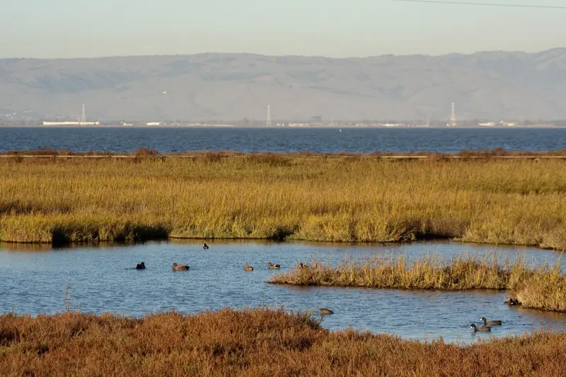
The Baylands Nature Preserve covers 1,940 acres at the east end of Embarcadero Road. The city calls it one of the largest tracts of undisturbed marshland left on San Francisco Bay. About 15 miles of multi-use trails run along the levees, past tidal sloughs, freshwater ponds and open mudflats.

Start at the Lucy Evans Baylands Nature Interpretive Center. The building stands on pilings at the edge of the marsh. A boardwalk about a quarter mile long runs from it across the pickleweed to open water. The boardwalk was rebuilt and reopened in 2019 after years of partial closure. Nearby you will find the Duck Pond, which began life as a saltwater swimming pool in the 1930s. The grassy hills of Byxbee Park rise just to the south.

The Baylands are at their best in winter, when migrating ducks and shorebirds arrive by the thousands. Sunsets over the marsh are also hard to beat. Our full Baylands guide covers trails, birding seasons and parking.

Tidal marsh and pickleweed at the Palo Alto Baylands
Pickleweed and tidal channels at the Baylands. The marsh turns red and gold in the fall. Photo: J Doll, Wikimedia Commons, CC BY 3.0
Advertisement

Foothills Nature Preserve

Foothills Nature Preserve sits off Page Mill Road above Interstate 280. It covers about 1,400 acres, close to a tenth of the land in Palo Alto. Most of it was bought from the physician Russel Lee after voters approved the purchase in 1959. The park opened in 1965 as Foothills Park.

For most of its life the park admitted only Palo Alto residents and their guests. After protests and a lawsuit, the city opened it to everyone on December 17, 2020. The City Council renamed it Foothills Nature Preserve in 2021. Today there is a daily vehicle fee and a cap on the number of visitors inside at one time.

Inside you will find Boronda Lake, a nature interpretive center, picnic lawns and about 15 miles of trails. Vista Hill looks out over the bay on clear days. Our Foothills Nature Preserve guide covers fees, the capacity limit and the best loops.

Pearson-Arastradero Preserve and Esther Clark

Enid W. Pearson-Arastradero Preserve is the friendly middle ground between the flat bay and the steeper foothills. It covers 622 acres of rolling grassland and oak woodland at 1530 Arastradero Road. About 10 miles of trails loop through it. Hikers, cyclists and horseback riders share them, so bikes are welcome here in a way they are not on most Foothills trails.

The trail map lists short loops that suit most fitness levels. The Redtail Loop climbs steeply through grassland for about 1.5 miles. The Arastradero Creek Trail follows a shaded creek for about 1.4 miles. A side trail leads to small Arastradero Lake. A gateway visitor center near the parking lot has a scale model of the preserve and exhibits on local plants and animals.

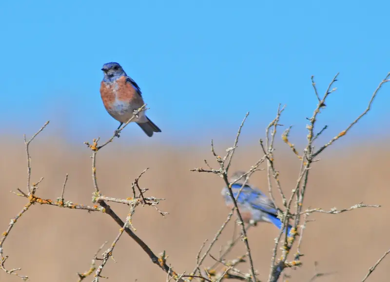
The preserve is open from 8 a.m. to sunset. Some trails are seasonal and close after heavy rain until the ground firms up. Dogs must be on leash. Deer, coyotes and bobcats live here and western bluebirds are common in the open grassland.

Esther Clark Park is a much smaller and quieter preserve of grass and oaks in the foothills on the city's southwest edge. It has no facilities to speak of. It is a good spot to sit with a view at sunset. Dr. Esther Clark, a founder of the Palo Alto Medical Clinic, sold the land to the city on the condition that it stay open space.

Western bluebirds perched at Pearson-Arastradero Preserve
Western bluebirds at Pearson-Arastradero Preserve. Look for them on fence posts and low branches. Photo: Schmiebel, Wikimedia Commons, CC BY-SA 3.0

The Dish and Stanford trails

The Dish is the walk that everyone in town seems to know. It loops through Stanford's foothills around a 150-foot radio telescope built in 1961. The paved route is about 3.5 miles with steady climbs and almost no shade. Stanford sets its own hours by month and bans dogs and bikes. Read our Dish guide for entrances, hours and tips.

Stanford also maintains other walking routes. The university lists the Perimeter Trail and the Matadero Deer Creek Trail as nearby options. The flat campus itself makes a fine walk. Start on Palm Drive, then circle the Main Quad and the Arizona Cactus Garden. Our Stanford visitor guide has the details.

Advertisement

City parks worth knowing

Rinconada Park

Rinconada Park on Middlefield Road is the city's classic central park. It has big shade trees, picnic lawns, playgrounds and the public Rinconada Pool. The Junior Museum and Zoo sits right next door. It is an easy stop if you are staying near downtown or exploring Crescent Park and the older neighborhoods.

Mitchell Park

Mitchell Park is a 21.4-acre district park in south Palo Alto. It holds the Magical Bridge Playground, which opened in 2015 and was designed so children and adults of every ability can play together. The park also has tennis and pickleball courts, a fenced dog park and the Mitchell Park Library next door.

Bol Park and its bike path

Bol Park sits in Barron Park. A paved path runs through it along an old rail line and continues toward the Gunn High School area. It is one of the most pleasant car-free connections in the city and a handy way to reach Arastradero by bike.

Biking in Palo Alto

Palo Alto is flat on its eastern side and built around bikes. The best-known route is the Bryant Street bike boulevard. Palo Alto created the first bicycle boulevard in the United States here. It is now named for Ellen Fletcher, a Holocaust survivor and one of the country's first bike activists. The street is designed to keep car traffic light and slow, so riders can cross much of the city north to south on quiet streets.

Other good rides:

  1. The Bay Trail and Baylands levees. Flat gravel and paved paths along the shore. Wind picks up most afternoons.
  2. Bol Park path to Arastradero. A gentle climb from Barron Park into the preserve, where bikes are allowed on most trails.
  3. Page Mill Road and the foothills. A serious road climb shared with cars. Bikes may only use the paved roads inside Foothills Nature Preserve.
  4. Stanford campus. Flat and full of bike lanes. Watch for student traffic between classes.

Helmets are required on the city's preserve trails. If you did not bring a bike, you can compare bike rentals in the Bay Area. Our getting around guide covers buses, trains and bike parking.

Birding

Birders come to Palo Alto from far away for the Baylands. Winter is peak season. From late fall through early spring the marsh fills with ducks, avocets, stilts, curlews and other shorebirds on the Pacific Flyway. The highest winter tides push secretive marsh birds such as the endangered Ridgway's rail toward the edges, where they are easier to spot.

The foothills offer a different list. Look for acorn woodpeckers in the oaks on the Dish, wild turkeys on the lawns at Foothills Nature Preserve and western bluebirds and hawks over Arastradero. Bring binoculars and arrive early. Birds are most active in the first hours after sunrise and the trails are quieter too.

Dogs and trail rules

Rules change from one preserve to the next. Here is a quick summary, but always check the city's rules page before you go.

PlaceDogsBikes
Baylands Nature PreserveOn leash, not on Renzel Ponds trailsYes, helmet required
Foothills Nature PreserveOn leash, weekdays onlyPaved roads only
Pearson-Arastradero PreserveOn leashYes, helmet required
Esther Clark ParkOn leashYes, helmet required
Stanford DishNo, except service animalsNo

In open space the leash can be no longer than six feet. Dogs can run free only in the city's fenced dog parks at Mitchell, Peers, Greer and Hoover parks. The dog park page lists the rules, including a limit of three dogs per person.

Good to know

  • Most city preserves open at 8 a.m. and close at sunset. Gates lock at closing time.
  • Drones and other remote-control devices are banned in the preserves.
  • Smoking, fires and feeding wildlife are banned across the open space system.
  • Poison oak, ticks and rattlesnakes are part of life in the foothills. Stay on marked trails.

In this section

Accessible trailsTen paved or firm trails near Palo Alto that agencies describe as accessible for wheelchairs and strollers, with lengths, surfaces, parking, dog rules and fees.Adobe CreekAdobe Creek from Black Mountain through Los Altos Hills, Los Altos and south Palo Alto to the Baylands, with the 101 bike bridge and the Adobe Creek Loop Trail.Almaden Quicksilver County ParkAlmaden Quicksilver County Park in south San Jose: old mercury mine trails, the three entrances, free parking, dog and bike rules, the mining museum and safety.Alum Rock ParkAlum Rock Park in east San Jose: California's oldest city park, its mineral springs and creek trails, the hours, free parking, the no-dogs rule and the drive.Alviso Marina County ParkAlviso Marina County Park in San Jose: the boardwalk, refuge levees, the boat launch, dog and bike rules, hours, parking and the story of the old port town.BackpackingBackpacking near Palo Alto: Black Mountain camp permits, Castle Rock trail camps, Skyline to the Sea status, Henry W. Coe permits and fees and what to carry.Bay view hikesTen bay view hikes near Palo Alto, from marsh levees to foothill lookouts, with published distances, dog and bike rules, parking, fees and the best seasons.Baylands Nature PreserveVisit the Palo Alto Baylands Nature Preserve. The boardwalk, Lucy Evans nature center, winter birding, Byxbee Park, the Duck Pond, sunsets and parking tips.Beaches near Palo AltoBeaches near Palo Alto: Half Moon Bay, San Gregorio, Pomponio, Pescadero and Santa Cruz state beaches, with fees, dog rules, sneaker wave safety and routes.Best hikes near Palo AltoThe best hikes in and near Palo Alto: the Dish, Arastradero, Foothills, Windy Hill, Rancho San Antonio, Russian Ridge, Huddart and Purisima Creek redwoods.Biking in Palo AltoWhere to ride a bike in Palo Alto: the Bryant Street bike boulevard, Bay Trail, Bol Park path, Stanford and the hills, plus Caltrain bike rules and tips.BirdwatchingWhere to watch birds in Palo Alto by season. Baylands tides and rails, the Lucy Evans center, Arastradero bluebirds, foothill raptors and local field trips.Bol Park and its bike pathGuide to Bol Park in Palo Alto's Barron Park: the car-free bike path on an old rail line, Matadero Creek, the Barron Park donkeys and how to visit them kindly.Boulware ParkBoulware Park in Ventura reopened in April 2025 after a $4.2 million expansion to 2.4 acres, with playgrounds, basketball courts, BBQ grills and picnic tables.Bowden ParkJerry Bowden Park on High Street: a 2-acre garden park by the California Avenue station, redesigned in 1960 by landscape architect Robert Royston.Byxbee ParkByxbee Park turned Palo Alto's old landfill into grassy hills with land art and wide bay views. History, the Pole Field and Wind Wave, trails, rules and tips.Camping near Palo AltoCamping near Palo Alto: Black Mountain backpack camp, Sanborn, Uvas Canyon, Memorial Park, Portola, Butano and Big Basin status and how each one takes bookings.Castle Rock State ParkCastle Rock State Park on Skyline: climbing on Castle Rock and Goat Rock, the 1.3-mile falls walk, trail camp status, the $10 fee, hours, rules and safety tips.Coal Creek PreserveCoal Creek Open Space Preserve near Skyline and Page Mill: Cloud's Rest, the shaded Crazy Pete's loop, a winter waterfall, dog and bike rules plus parking.Community gardensHow to get a plot in a Palo Alto community garden: the five city sites, who can apply, the waitlist, the organic rules, work hours and what grows well here.Coyote Hills Regional ParkCoyote Hills Regional Park in Fremont: the Ohlone village site and visitor center, the paved Bayview Trail, the marsh boardwalk, hours, fees, dogs, the drive.Coyote Point Recreation AreaCoyote Point Recreation Area in San Mateo: the bay beach and windsurfing, trails, CuriOdyssey, playground construction, winter hours, the $6 fee and dog rules.Dog parks and dog-friendly placesPalo Alto's four fenced dog parks with hours and rules, leash laws in parks and preserves and the best dog-friendly trails nearby, including Windy Hill.Dog-friendly hikesDog-friendly hikes near Palo Alto: Arastradero, the Pulgas Ridge off-leash area, Windy Hill and coast trails, plus where dogs are banned and heat tips.Don Edwards SF Bay RefugeDon Edwards San Francisco Bay National Wildlife Refuge: Fremont visitor center, Alviso center status, levee trails, birds, dog rules and the Dumbarton pier.Easy hikesNine easy hikes near Palo Alto with published distances and climbs, plus dog and bike rules, parking, fees and the best season for each gentle trail.Ed R. Levin County ParkEd R. Levin County Park in Milpitas: trails toward Monument Peak, Sandy Wool Lake, the hang gliding launches, the off-leash dog park, fees, hours and safety.El Camino ParkEl Camino Park at 155 El Camino Real: Palo Alto's oldest park: lighted turf fields by the Caltrain station and the Hostess House, with a water reservoir below.El Corte de Madera CreekEl Corte de Madera Creek Preserve on Skyline: tafoni sandstone, an old-growth redwood, the Resolution memorial, parking, bike and horse rules plus safety tips.Eleanor Pardee ParkEleanor Pardee Park on Center Drive: 9.6 acres of lawn, playgrounds, picnic areas and community gardens, its 1920 gift to the city and the new restroom plan.Esther Clark Nature PreserveEsther Clark Park is a small grass and oak preserve in the Palo Alto foothills. Where it is, how to get in, what to expect and the story behind its name.Fall colorsWhere to see fall color in Palo Alto: pistache, sweetgum and ginkgo street trees, Stanford's campus, black oaks and maples in the hills, plus when leaves turn.FishingWhere to fish near Palo Alto: Boronda Lake, bay piers, Stevens Creek and Lexington reservoirs and Pillar Point, with 2026 license fees and mercury advice.Foothills Nature PreserveGuide to Foothills Nature Preserve in Palo Alto. Its residents-only past, entry fee and visitor cap, Boronda Lake, the Los Trancos Trail and nearby hikes.Fremont Older PreserveFremont Older Open Space Preserve above Cupertino and Saratoga: the Seven Springs Loop, Hunters Point, Maisie's Peak, dog and bike rules, parking plus history.GolfGolf in and near Palo Alto: the rebuilt Baylands Golf Links on the bay, who can play Stanford Golf Course, the public Stanford range and Shoreline Golf Links.Greer ParkGreer Park in Midtown Palo Alto: 22 acres with the 1991 tri-bowl skate park, sports fields, playground, small dog run, restrooms and its seafaring namesake.Hang gliding and paraglidingHang gliding and paragliding near Palo Alto: Ed R. Levin launches, Windy Hill permits, Fort Funston and Mussel Rock, tandem flights, ratings and where to watch.Hard hikesNine hard hikes near Palo Alto, from Black Mountain to Mission Peak and Mount Umunhum, with published distances, climbs, rules, fees and heat safety tips.Henry W. Coe State ParkHenry W. Coe State Park near Morgan Hill: the Coe Ranch, Hunting Hollow and Dowdy entrances, the $8 fee, Frog Lake and China Hole hikes, dogs, heat and creeks.Heritage ParkHeritage Park at 300 Homer Avenue: a two-acre lawn with a sentinel redwood, a playground around a transplanted oak, picnic tables and the May Fete fair.Hoover ParkHoover Park on Cowper Street in Midtown: 4.2 acres with a playground, tennis and basketball courts, a ball field, restrooms, a shady dog run and a dry creekbed.Hopkins Creekside ParkHopkins Creekside Park: about 12.4 acres of oaks, picnic tables and paths along San Francisquito Creek in Downtown North, given by Timothy Hopkins.Horseback ridingHorseback riding near Palo Alto: guided beach and trail rides, lessons at Stanford's Red Barn and the rules for riders in Midpen, county and state parks.Johnson ParkJohnson Park at 268 Waverley Street: a 2.5-acre block in Downtown North with a playground, basketball court and community garden, plus history and directions.Juana Briones ParkJuana Briones Park on Maybell Avenue: a 4.1-acre former apricot orchard with a train playground, basketball, shade trees, picnic tables and a history sign.Kayaking and paddlingKayaking and paddleboarding near Palo Alto: the Baylands launch and its tides, the lost Palo Alto Yacht Harbor, Shoreline Lake rentals and bay safety tips.La Honda Creek PreserveLa Honda Creek Preserve near La Honda: Sears Ranch Road parking, the Grasshopper Loop, the free Allen Road permit, seasonal dog rules, bikes and cattle safety.Lawn bowling at Bowling Green ParkTry lawn bowling at Bowling Green Park, 474 Embarcadero Road: the Palo Alto Lawn Bowls Club's free drop-in lessons, draw games, dues and its green from 1935.Long Ridge PreserveLong Ridge Open Space Preserve on Skyline Boulevard: the 4.3-mile Peters Creek loop, the Wallace Stegner bench, dog-friendly trails, parking areas and rules.Loop hikesTen loop hikes near Palo Alto from 1.5 to 7.2 miles, with published distances and climbs, which way to walk, dog and bike rules, parking, fees and seasons.Los Trancos PreserveLos Trancos Open Space Preserve on Page Mill Road: the 1.5-mile San Andreas Fault Trail stop by stop, the Triple Loop, parking, rules and safety tips.Matadero CreekMatadero Creek from Los Altos Hills to the Palo Alto Flood Basin: Bol Park, the concrete channel, flood work, the renaturalization study and where to see it.Mission Peak Regional PreserveMission Peak Regional Preserve in Fremont: Ohlone College and Stanford Avenue trailheads, hours, the $4 college parking fee, dogs, heat safety and the drive.Mitchell Park and Magical BridgeGuide to Mitchell Park in south Palo Alto: the Magical Bridge Playground, Mitchell Park Library and Community Center, the dog park, courts and Adobe Creek.Monte Bello PreserveMonte Bello Open Space Preserve above Palo Alto: Black Mountain, the Stevens Creek Nature Trail, the backpack camp permit rules, parking, bikes and safety.Mountain bikingMountain biking near Palo Alto: which Midpen, county and state park trails allow bikes, El Corte de Madera from Skeggs Point, Russian Ridge and helmet rules.Ocean view hikesTen hikes near Palo Alto with Pacific views, from Skyline ridge summits to paved coastal paths, with distances, dog and bike rules, parking, fees and fog tips.Outdoor rock climbingOutdoor rock climbing near Palo Alto: Castle Rock bouldering, Goat Rock, Sanborn crags on Skyline, rain closures, park rules, gear and going from gym to rock.Pearson-Arastradero PreserveGuide to Pearson-Arastradero Preserve in Palo Alto: 622 acres of grassland and oaks, about 10 miles of trails, the gateway facility, parking, dogs and bikes.Peers ParkPeers Park in Evergreen Park: the city's largest dog run, two play structures, tennis courts, a rentable field house and redwoods grown from space-flown seeds.Picchetti Ranch PreservePicchetti Ranch Preserve in Cupertino: the Zinfandel and Bear Meadow trails, the historic winery, Montebello Road parking and the no dogs or bikes rules.Picnic spotsThe best picnic spots in Palo Alto and how to book a group site: Rinconada and Mitchell Park reservations, Foothills Nature Preserve rules and the Baylands.Portola Redwoods State ParkPortola Redwoods State Park from Palo Alto: the steep drive, camping and trail camp status, Old Tree, Tiptoe Falls, the Peters Creek Grove, fees and dog rules.Pulgas Ridge PreservePulgas Ridge Open Space Preserve in San Carlos: the 17.5-acre off-leash dog area, the 2-mile loop, the accessible Cordilleras Trail, parking and Midpen rules.Purisima Creek RedwoodsPurisima Creek Redwoods Preserve above Half Moon Bay: the Redwood Trail, routes from Skyline, the Purisima Creek Trail, three parking areas, rules and safety.Ramos ParkRamos Park at 800 East Meadow Drive: a 4.4-acre south Palo Alto park, reopened in April 2025 with a new restroom and playground, plus its 1958 history.Rancho San Antonio trailsTrail-by-trail guide to Rancho San Antonio: the PG&E or Abbors Trail, Wildcat Canyon, Rogue Valley, Deer Hollow, High Meadow, Black Mountain and parking.Ravenswood PreserveRavenswood Open Space Preserve in East Palo Alto: the paved Bay Trail levee, boardwalk, birding, Bay Road parking, bike and e-bike rules and the no dogs rule.Redwood hikesNine redwood hikes near Palo Alto, from a flat quarter mile to old-growth giants, with published distances, climbs, dog rules, parking, fees and seasons.Ride: Alpine RoadRide Alpine Road from Stanford through Ladera and Portola Valley to the end of the pavement below Skyline: distance, climbing, stops, dirt options and closures.Ride: Baylands and ShorelineA flat bike ride from Palo Alto's California Avenue station through the Baylands to Shoreline and the Stevens Creek Trail, ending at Mountain View Caltrain.Ride: Cañada RoadRide Cañada Road from Palo Alto and catch Bicycle Sunday, when San Mateo County closes 3.8 miles to cars from 9 a.m. to 3 p.m. Route, stops and 2026 dates.Ride: family greenwaysAn easy, low-traffic family bike ride in Palo Alto: the Bryant Street bike boulevard from downtown to Mitchell Park, with distances, stops and crossings.Ride: Los Altos Hills loopA Los Altos Hills bike loop from Palo Alto: Arastradero, Purissima, Elena and Moody roads, home on Foothill Expressway, with climbing, stops and road notes.Ride: Palo Alto to Half Moon BayRide a bike from Palo Alto to Half Moon Bay over Old La Honda or Kings Mountain and Highway 92 or 84: distance, climbing, traffic warnings and the way home.Ride: the Arastradero loopA 15-mile Arastradero Road bike loop from Palo Alto's California Avenue station, back on Alpine Road and the Dish, with climbing, stops and closure notes.Ride: the Portola Valley LoopRide the Portola Valley Loop from Palo Alto: Arastradero, Alpine, Portola Road and Sand Hill, with distance, climbing, stops, traffic notes and closures.Ride: the Stanford perimeterA 9-mile bike loop around Stanford from Palo Alto station: Sand Hill Road, Junipero Serra past the Dish, the Stanford Perimeter Trail, stops and safety.Rinconada ParkGuide to Rinconada Park in central Palo Alto: the public pool, playgrounds, the redwood Magic Forest, the Junior Museum and Zoo next door and the library.Road cycling climbsRoad bike climbs near Palo Alto: Old La Honda, Page Mill, Kings Mountain, Tunitas Creek and Montebello, with distances, grades and Highway 84 safety notes.Robles ParkRobles Park at 4116 Park Boulevard: a 4.7-acre Charleston Meadows park with two playgrounds, grills, picnic tables, basketball and a softball field.Running routesThe best running routes in Palo Alto: the Stanford Dish loop, flat Baylands and Bay Trail miles, Bryant Street, Stanford campus, foothill trails and a local race.Russian Ridge PreserveRussian Ridge Open Space Preserve at Skyline and Page Mill: Borel Hill, spring wildflowers, Mindego Hill, Alpine Pond, the four parking areas and the rules.Sailing and windsurfingSailing and windsurfing near Palo Alto: Shoreline Lake lessons, Coyote Point wind, Foster City lagoon, Redwood City sailing school and clubs and bay safety.Sam McDonald County ParkSam McDonald County Park near La Honda: Heritage Grove redwoods, trails, hours, fees, the no dogs rule, horse camp and the Stanford man behind the name.San Francisco Bay TrailHow to walk or ride the San Francisco Bay Trail through Menlo Park, East Palo Alto, Palo Alto and Mountain View. Segments, access points, surfaces and tips.San Pedro Valley ParkSan Pedro Valley Park in Pacifica: the Brooks Falls loop, Montara Mountain views, steelhead creeks, winter hours, the $6 fee, the no-dogs rule and trails.Sanborn County ParkSanborn County Park above Saratoga: redwood trails, hike-in and RV camping, Lake Ranch, dog and bike rules, vehicle fees, parking limits and seasonal closures.Saratoga Gap PreserveSaratoga Gap Open Space Preserve at Skyline and Highway 9: the Bay Area Ridge Trail, links to Castle Rock and the Saratoga to the Skyline Trail, parking, rules.Seale ParkHenry W. Seale Park on Stockton Place in Midtown: 4.3 acres beside Matadero Creek with a meadow, playgrounds, soccer, basketball and picnic tables.Shaded hikesNine shaded hikes near Palo Alto under redwoods, oaks and fir, with published distances, dog and bike rules, parking, fees and the best season for each.Short hikesTen short hikes near Palo Alto you can finish in under an hour, with published distances and climbs, dog and bike rules, parking, fees and the best seasons.Sierra Azul PreserveSierra Azul Preserve and Mount Umunhum: the summit road and 3.9-mile trail, the Cold War radar tower, hours, parking areas, dog limits and safety in the heat.Skyline Ridge PreserveSkyline Ridge Open Space Preserve near Palo Alto: Horseshoe Lake, Alpine Pond, the Daniels Nature Center hours, easy trails, parking, rules and the tree farm.Stevens Creek County ParkStevens Creek County Park in Cupertino: the reservoir, picnic areas, trails to Fremont Older, dog and bike rules, vehicle fees, boating and fishing advice.Sunol Regional WildernessSunol Regional Wilderness near Fremont: the Alameda Creek Overlook (Little Yosemite), trail mileage, hours, the $5 weekend fee, dogs and fire rules.Sunset spotsWhere to watch the sunset near Palo Alto: the Dish, Byxbee Park, the Baylands, Windy Hill and Skyline Boulevard, with closing times as each park posts them.SurfingSurfing near Palo Alto: beginner waves at Linda Mar and Cowell Beach, Half Moon Bay breaks, Santa Cruz surf schools, wetsuits, safety and watching Mavericks.Tennis and pickleballWhere to play tennis and pickleball in Palo Alto. How city courts and reservations work, the Mitchell Park pickleball courts, the court debate and local clubs.Terman ParkTerman Park, 7.7 acres behind Ellen Fletcher Middle School: soccer and softball fields, tennis and basketball courts and paths, with school-hours rules.The Stanford DishHow to hike the Stanford Dish loop in Palo Alto. Distance and climb, the four gates, seasonal hours set by Stanford, rules, wildlife and the best times to go.Thornewood PreserveThornewood Open Space Preserve in Woodside: the easy walk to Schilling Lake, ruins of the Schilling spice estate, the Thorne house, dog rules and the tiny lot.Tide poolingTide pooling near Palo Alto: Fitzgerald Marine Reserve with its closed ramp, Pescadero, Bean Hollow and Natural Bridges, plus low tide planning and the rules.Trail runningTrail running near Palo Alto: Arastradero, Rancho San Antonio, Windy Hill, Huddart and Purisima routes with distances, winter 2026 to 2027 races and rules.Trees and the urban forestPalo Alto's urban forest: street trees, the Urban Forest Master Plan, protected oaks and redwoods, heritage trees, the Great Oak Count and El Palo Alto.Vasona Lake County ParkVasona Lake County Park in Los Gatos: paddle and row boat rentals, the Los Gatos Creek Trail, the Youth Science Institute, the little train, fees and dog rules.Waterfalls near Palo AltoSeasonal waterfalls near Palo Alto: Uvas Canyon, Castle Rock, Tiptoe and Brooks falls, Berry Creek Falls status at Big Basin and the safe route to Alamere.Weisshaar ParkFrederick W. Weisshaar Park on Dartmouth Street: a 1.1-acre College Terrace square with two public tennis courts and a lawn, named for an original landowner.Werry ParkWilliam C. Werry Park on Dartmouth Street: a 1.1-acre College Terrace square from the 1887 plan with a playground, lawn and a renovation listed for 2028.Whale watchingWhale watching near Palo Alto: Monterey and Moss Landing boat tours, gray whale trips, seasons by species and shore spots at Pigeon Point and Davenport.WildflowersWhere to see spring wildflowers near Palo Alto: Edgewood's serpentine grassland, Russian Ridge, Arastradero and the Dish, with bloom timing and trail rules.

Frequently asked questions

What is the best easy hike in Palo Alto?

The Stanford Dish loop is the most popular choice. It is a paved path of about 3.5 miles with steady hills and wide views. For flat walking, the levee trails at the Baylands Nature Preserve are easier and good for birding.

Is Foothills Nature Preserve open to non-residents?

Yes. The park was residents only for decades but opened to everyone on December 17, 2020. The city charges a daily vehicle fee and limits how many people can be inside at once, so the gate can close on busy weekends.

Can I bring my dog on Palo Alto trails?

Dogs are allowed on leash in the Baylands and Pearson-Arastradero Preserve. Foothills Nature Preserve allows leashed dogs on weekdays only. Dogs are not allowed on the Stanford Dish except service animals.

Where can I ride a bike in Palo Alto?

The Bryant Street bike boulevard runs north to south through the city with few cars. The Bay Trail and Baylands levees are flat and scenic. Bol Park bike path links Barron Park to the Gunn High School area.

When are the open space preserves open?

The city's preserves are generally open from 8 a.m. to sunset. Exact closing times change with the season and are posted at each entrance. The Stanford Dish sets its own hours by month.
Advertisement
Advertisement