On this page
Palo Alto sits halfway down the San Francisco Peninsula, between San Francisco and San Jose. That location is the reason it is so easy to reach. Two major airports are within about 20 miles and a third is across the bay. The electric Caltrain line stops right at the edge of downtown. You can land at SFO in the morning and be eating lunch on University Avenue without ever renting a car.
This page covers every realistic way in. It starts with the three airports, then covers driving, long distance trains and buses. It ends with a few booking tips. Once you arrive, our guide to getting around Palo Alto picks up the story.
Which airport should you fly into?
Most visitors choose between San Francisco International (SFO) and San Jose Mineta International (SJC). Oakland is the third option. Each has a clear profile.
| Airport | Distance to Palo Alto | Best for | Transit option |
|---|---|---|---|
| SFO | About 20 miles north | International flights, the most nonstop routes | BART to Millbrae, then Caltrain |
| SJC | About 15 miles southeast | Domestic flights, shorter lines | Free VTA Route 60, then Caltrain |
| OAK | Roughly 30 to 35 miles by road | Low fare carriers, East Bay trips | BART, then Caltrain at Millbrae |
Distances are approximate road miles to downtown Palo Alto. Drive times swing widely with traffic. A trip from SFO can take 25 minutes on a Sunday morning and well over an hour on a weekday afternoon.
From San Francisco International (SFO)
SFO is the main international gateway for Northern California. If you are flying in from overseas, this is almost certainly where you will land.
BART plus Caltrain
The cheapest route uses two trains. Ride the AirTrain to the BART station at the International Terminal. Take BART one stop south to Millbrae. At Millbrae, BART and Caltrain share a station, so you simply walk to the Caltrain platform and board a southbound train to Palo Alto. Millbrae is in Caltrain Zone 2 and Palo Alto is in Zone 3, so it counts as a two zone trip. The adult fare for two zones was $6.25 in October 2026 and is set to rise to $6.50 on January 1, 2027, according to the Caltrain fares page.
The weak point is the connection. Caltrain runs about four trains per hour at peak times and two off peak, while BART runs on its own pattern. Caltrain and BART publish a joint Millbrae transfer timetable that shows the wait for each connection. Check it before you land. Late at night, BART has been running slower trains between Millbrae and SFO during construction, so give yourself extra time on late arrivals.
SamTrans buses also serve the airport, including the overnight Route 397 that runs to the Palo Alto Transit Center. Our SFO guide covers every option in detail.
Rideshare, taxis and private transfers
Uber, Lyft and taxis all serve SFO. Follow the airport signs to the designated pickup areas. A ride to Palo Alto takes 25 to 60 minutes depending on traffic. If you are arriving after a long flight with family or heavy bags, a prebooked driver who meets you at arrivals removes the guesswork. You can book a fixed price SFO pickup in advance.
Robotaxis
SFO approved Waymo for passenger trips in January 2026. At launch the service was limited to a select group of riders, with pickups at the Rental Car Center on Level 1. Rules are still evolving, so open the Waymo app before you fly to see whether it offers your trip.
Rental cars
All the major rental brands operate from the SFO Rental Car Center, which you reach on the AirTrain. From there it is a straight shot south on US 101. You can compare SFO rental car prices across brands before you book.
From San Jose Mineta International (SJC)
SJC is the closest airport to Palo Alto and the easiest to get through. It handles mostly domestic flights, plus a handful of international routes.
For transit, take the VTA Route 60 bus from Terminal A or Terminal B. It is free to ride in either direction from the airport. Get off at Santa Clara Transit Center, which doubles as the Santa Clara Caltrain station. There you catch a northbound Caltrain to Palo Alto or California Avenue. Route 60 also connects to Milpitas BART if you are heading to the East Bay.
By car or rideshare the trip is usually 20 to 40 minutes. SJC was the first commercial airport in California to offer fully autonomous rides. Since November 2025, Waymo has picked up passengers at the ground transportation centers at both terminals. Riders can travel anywhere in Waymo's Bay Area service area, which includes Palo Alto.
From Oakland (OAK)
The Oakland airport now goes by the name Oakland San Francisco Bay Airport, though its code is still OAK. It sits on the east side of the bay, so getting to Palo Alto means crossing the water.
By transit, take the BART connector from the terminal to Coliseum station. Then ride BART to Millbrae and change to Caltrain. It works, but it is a long trip with two transfers. By car you cross either the San Mateo Bridge (State Route 92) or the Dumbarton Bridge (State Route 84). Both charge a toll in the westbound direction. Oakland makes sense if it has a much better fare or if you are also visiting the East Bay.
Driving to Palo Alto
Three roads run the length of the Peninsula and all of them pass through Palo Alto.
- US 101 (Bayshore Freeway) runs along the bay side of town. Exit at University Avenue for downtown, Embarcadero Road for the Baylands and the east side of downtown, or Oregon Expressway for Midtown and California Avenue.
- Interstate 280 follows the foothills on the west side. It is often calmer and more scenic than 101. Exit at Sand Hill Road for Stanford and Menlo Park, or Page Mill Road for Stanford Research Park and the foothills.
- El Camino Real (State Route 82) is the old mission road. It is slow, with many traffic lights, but it connects every Peninsula town and runs right past Stanford.
Parts of US 101 on the Peninsula have express lanes that need a FasTrak toll tag. If you rent a car, ask how the company bills tolls before you drive off. Weekday rush hours, roughly 7 to 10 a.m. and 3 to 7 p.m., are heavy in both directions. Once you are in town, see getting around for downtown parking rules and Stanford visitor parking.
Amtrak, Caltrain and intercity buses
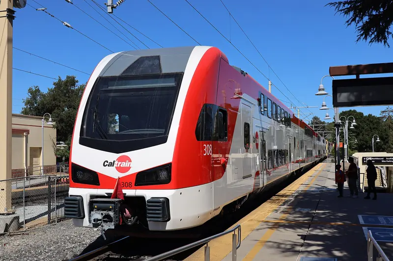
Caltrain is the backbone of rail travel on the Peninsula. Since September 2024 it has run fully electric trains between San Francisco and San Jose. Palo Alto station at 95 University Avenue is served by local, limited and express trains. Express trains make the run from San Francisco to San Jose in about an hour. From San Francisco's Fourth and King station to Palo Alto is a three zone trip.
Amtrak does not stop in Palo Alto. The nearest Amtrak station is San Jose Diridon, which is also a Caltrain station. The Coast Starlight stops there once a day in each direction on its run between Los Angeles and Seattle. The Capitol Corridor ends at Diridon after running from Sacramento through the East Bay. Amtrak Thruway Route 21 connects Diridon with the Central Coast, as far as San Luis Obispo and Santa Barbara. ACE trains from Stockton also end at Diridon. From any of them, change to a northbound Caltrain for Palo Alto. The Santa Cruz METRO Highway 17 Express is also an Amtrak Thruway route and honors Amtrak through tickets, as our Santa Cruz and Monterey guide explains.
Greyhound and FlixBus list their San Jose stop at 65 Cahill Street, inside the Diridon Station bus terminal, so the same Caltrain connection works. Caltrain has posted track changes at Diridon during construction running into December 2026, so allow a few extra minutes for the transfer.

Tips for booking flights
- Search all three airports. Fares to SFO, SJC and OAK can differ a lot for the same dates. Most flight search sites let you search the whole Bay Area at once. Try Kiwi.com to compare all three at once.
- Weigh time against price. SJC usually saves 30 to 60 minutes of ground travel compared with SFO. That can be worth a slightly higher fare on a short trip.
- Watch the big Stanford weekends. Flights and hotels both fill up around commencement in June and new student move-in in September. See plan your trip for the dates to know.
- Know your rights on delays. If your trip includes a flight covered by European passenger rules, such as a departure from the EU, you may be owed compensation for a long delay or cancellation. Services such as AirHelp handle the claim for a share of the payout.
Good to know
- Caltrain ended its Clipper discount on January 1, 2026. Clipper cards, contactless bank cards and phone wallets now pay the same fare.
- Tap on and tap off at the Clipper validators on the platform for every Caltrain ride.
- A regional transit funding measure is on the November 2026 ballot. Caltrain has warned that service could be cut if new funding does not come through, so check caltrain.com for the latest schedule.
When you arrive
Palo Alto station drops you at the foot of University Avenue. Downtown restaurants and hotels are a few minutes on foot. The Palo Alto Transit Center next to the station is where the free Stanford Marguerite shuttles and several bus lines begin. Turn the other way and Palm Drive leads straight to the Stanford campus. Read our Stanford visitor guide and the downtown guide to plan your first afternoon. If you still need a bed for the night, start with where to stay.
In this section
Frequently asked questions
What is the closest airport to Palo Alto?
San Jose Mineta International Airport (SJC) is the closest, about 15 miles southeast. San Francisco International (SFO) is about 20 miles north and has far more flights, especially international ones. Oakland is across the bay and usually the longest trip.
How do I get from SFO to Palo Alto by public transit?
Take BART from the SFO station to Millbrae, then transfer to a southbound Caltrain to Palo Alto or California Avenue. Allow roughly an hour or more depending on how the connection lines up. BART and Caltrain publish a joint transfer timetable for Millbrae.
Is there a direct train from San Jose airport to Palo Alto?
No train goes into SJC. Take the free VTA Route 60 bus from the terminal to Santa Clara Transit Center, then ride Caltrain north to Palo Alto. A rideshare or taxi is faster if you have luggage.
Can I take a Waymo from the airport to Palo Alto?
Waymo began public pickups at San Jose airport in November 2025 and its Bay Area service area includes Palo Alto. At SFO, Waymo was approved in early 2026 for a limited group of riders at the Rental Car Center. Check the Waymo app for what is offered on your travel date.
Do I need a car to visit Palo Alto?
Not if you stay downtown or near a Caltrain station. Caltrain, the free Stanford Marguerite shuttle and rideshare cover most visitor needs. A car helps for the foothills, the coast or trips around the wider Bay Area.