On this page
A good hike does not need a whole morning. Around Palo Alto you can see a salt marsh, a redwood grove, a sandstone waterfall or a 360-degree view in less time than it takes to watch a movie. The trick is knowing which trailheads put the reward close to the car.
This guide picks ten short walks, all under two miles. Distances come from the managing agency or our park pages. At about 2 miles an hour on easy trail, each fits in under an hour of walking, though the drive to Skyline adds 30 minutes or more each way. If you want a little more distance at the same easy grade, see our easy hikes guide.
The short hikes at a glance
| Walk | Distance | Climb | Drive from downtown |
|---|---|---|---|
| Baylands boardwalk | About 0.5 mile round trip | Flat | About 10 minutes |
| Byxbee Park Hills loop | 30 to 45 minutes | Gentle | About 10 minutes |
| Arastradero Lake | 1.14 miles round trip | One 40-foot rise | About 15 minutes |
| Purisima Redwood Trail | 0.25 mile | Flat | About 45 minutes |
| Windy Hill from Skyline | 0.6 mile, or 1-mile loop | Small | About 35 minutes |
| Alpine Pond, Skyline Ridge | About 0.5-mile loop | Level | About 35 minutes |
| San Andreas Fault Trail | 1.5-mile loop | Easy | About 25 to 30 minutes |
| Crazy Pete's loop, Coal Creek | 1.7-mile loop | Not published | About 30 minutes |
| Castle Rock Falls | 1.3 miles round trip | 320 feet | About 50 minutes |
| Sequoia Nature Trail, Portola | 0.75-mile loop | 67 feet | About an hour |
Drive times are our rough estimates in light traffic.
In town: walks you can do at lunch
Baylands boardwalk
The boardwalk from the Lucy Evans nature center crosses the salt marsh for about a quarter mile to open water. It was rebuilt in 2019 to accessibility standards. In 20 minutes you can be out and back with pelicans and egrets for company.
- Dogs and bikes: leashed dogs allowed in the preserve, except on trails around the Renzel Ponds. Bikes on levees.
- Parking and fees: free lots at the end of Embarcadero Road. 8 a.m. to sunset.
- Best season: November to February for birds. Go at high tide for birds close in.
- Watch for: afternoon wind and no shade.
Our Baylands guide has more.
Byxbee Park Hills loop
Next door, a loop over the grassy hills and past the Pole Field takes 30 to 45 minutes at an easy pace. The view west over the marsh to the mountains is the best in the preserve in late afternoon.
- Dogs and bikes: leashed dogs. Walking and bicycling trails.
- Parking and fees: free. The lot gate closes at the time posted at the entrance.
- Best season: fall and winter evenings.
See our Byxbee Park guide.
Arastradero Lake
The city lists this trail at 0.57 mile each way, mostly flat with one short rise of 40 feet. Our park page suggests about 45 minutes with small children. Look for turtles and herons at the pond before turning back.
- Dogs and bikes: leashed dogs every day. Bikes share the trail.
- Parking and fees: free lot at 1530 Arastradero Road. 8 a.m. to sunset.
- Best season: spring.
- Watch for: rattlesnakes on warm days.
Our Arastradero guide lists longer loops.
Up Page Mill Road
San Andreas Fault Trail, Los Trancos
Midpen lists this as an easy 1.5-mile self-guided loop. Numbered posts mark the 1906 fault break, a rebuilt offset fence and boulders carried from Loma Prieta. Download Midpen's free trail guide before you lose signal. Allow extra time if you read every station.
- Dogs and bikes: not allowed.
- Parking and fees: 23 spaces plus 1 accessible; Monte Bello lot across the road. Free.
- Best season: clear days any time of year.
Midpen posts the trail guide online. See our Los Trancos guide.
Crazy Pete's Road and Coal Road loop, Coal Creek
Midpen describes a 1.7-mile loop through oak woodland past a small seasonal waterfall, almost entirely shaded. It is the best short hike for a hot afternoon with a dog.
- Dogs and bikes: leashed dogs, but not in the creek. Bikes allowed with helmets.
- Parking and fees: Upper Alpine roadside, 7 spaces. Free.
- Best season: winter for the waterfall, summer for shade.
Our Coal Creek guide has parking tips.
On Skyline Boulevard
Windy Hill from Skyline
Midpen's 0.6-mile trail between the two Skyline parking areas detours to the summit, where it describes a 360-degree view of the bay and the Pacific. Return along Skyline for a loop of about a mile.
- Dogs and bikes: leashed dogs on designated trails, including the Anniversary Trail. Bikes on designated trails.
- Parking and fees: small roadside lots on Skyline. Free.
- Best season: clear fall evenings. Midpen stays open half an hour after sunset.
See our Windy Hill guide.
Alpine Pond, Skyline Ridge
Midpen describes a level, smooth loop of about half a mile around the pond, with a wheelchair-accessible floating pier and viewing scope. The Daniels Nature Center beside it opens on weekends from April through November.
- Dogs and bikes: no dogs. Bikes on designated trails.
- Parking and fees: reach it through a pedestrian tunnel from the Russian Ridge lot, 37 spaces. Free.
- Best season: spring for pond life.
Our Skyline Ridge guide covers Horseshoe Lake too.
Purisima Redwood Trail
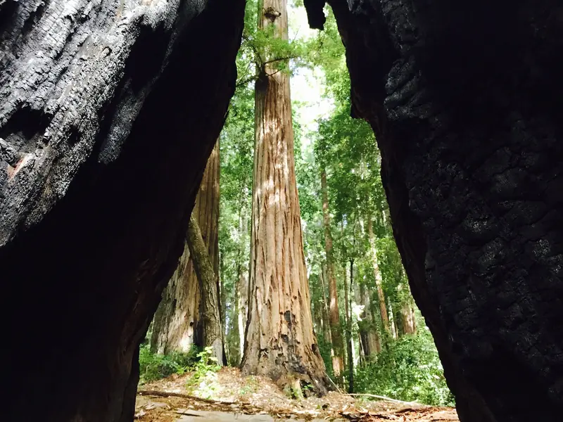
The shortest walk here: a flat 0.25 mile through tall redwoods just off Skyline, with accessible picnic tables and a restroom. Midpen says it suits visitors of all abilities.
- Dogs and bikes: no dogs. Bikes on designated trails elsewhere in the preserve.
- Parking and fees: Redwood roadside parking, 11 spaces plus 2 accessible. Free.
- Best season: summer, when fog drifts through the trees.
See our Purisima Creek Redwoods guide.

Worth the longer drive
Castle Rock Falls
State Parks lists the walk from the Kirkwood lot to the viewing platform above 75-foot Castle Rock Falls at 1.3 miles round trip with 320 feet of gain. The climb comes on the way back. The falls gush after rain and may trickle in drought.
- Dogs and bikes: dogs prohibited in the park. No bikes on this trail.
- Parking and fees: $10 per vehicle, $9 for seniors. 6 a.m. to sunset.
- Best season: after winter storms.
- Watch for: slick rock. Stay behind the railing. No cell reception.
Check the State Parks page for alerts. Our Castle Rock guide lists longer loops.
Sequoia Nature Trail, Portola Redwoods
Behind the visitor center, State Parks lists this loop at 0.75 mile with 67 feet of elevation change. It passes Shell Tree, the remains of a redwood State Parks says was about 2,000 years old. The Old Tree Trail, 1.2 miles round trip, is the other short option.
- Dogs and bikes: no dogs or bikes on trails.
- Parking and fees: $10 per vehicle. 6 a.m. to sunset.
- Best season: summer, when the seasonal bridge crosses Pescadero Creek.
See our Portola Redwoods guide.
Making a short hike work
Good to know
- Check closing times. Sunset now comes around 5 p.m. City preserves close at sunset; Midpen preserves half an hour after.
- Carry water even on short walks. Midpen provides none.
- Short does not mean safe from ticks or poison oak. Stay in the middle of the trail.
- Small Skyline lots fill on weekends. Weekday afternoons are easiest.
For a bigger outing on the same day, pair a short walk with a longer trail from our best hikes guide. No transit reaches the Skyline trailheads, so you can compare rental cars if you are visiting without one.
Frequently asked questions
What is a good short hike in Palo Alto?
The Baylands boardwalk runs about a quarter mile each way over the marsh and is free. The walk to Arastradero Lake is 0.57 mile each way and mostly flat. Both fit easily in under an hour.
Is there a short hike near Palo Alto with a waterfall?
Yes. State Parks lists the walk to Castle Rock Falls at 1.3 miles round trip with 320 feet of elevation gain, with the climb on the way back. The falls run best after winter rain. Coal Creek's 1.7-mile loop also passes a small seasonal waterfall.
What is the shortest redwood walk near Palo Alto?
The Redwood Trail at Purisima Creek Redwoods, just off Skyline Boulevard, is a flat 0.25 mile. Midpen says it suits visitors of all abilities. At Portola Redwoods, the Sequoia Nature Trail loops 0.75 mile with 67 feet of elevation change.
How long does it take to walk a mile on these trails?
On flat, easy trail most adults walk about 2 miles an hour with stops, so a 1.5-mile loop takes roughly 45 minutes. Add time for climbs, children or birdwatching.
Can I do a short hike after work in winter?
Yes, but check closing times. Daylight saving time ended November 1, so sunset comes around 5 p.m. City preserves close at sunset and Midpen preserves half an hour after sunset.