On this page
Palo Alto is one of the easier places in the Bay Area to visit without a car. The city is flat, its main districts sit along the Caltrain line and Stanford runs a free shuttle network that anyone can ride. Downtown, California Avenue and the Stanford campus are all within a couple of miles of each other. Many visitors walk, ride the train one stop or hop on a shuttle and never think about parking.
A car still helps for the foothills, the coast and trips around the wider region. This page covers each option in turn, from trains to parking, with links to the official pages for fares and rules that change. If you have not arrived yet, start with getting to Palo Alto.
Caltrain
Caltrain runs between San Francisco and San Jose with branch service south to Gilroy. Since September 21, 2024 the whole core line has run on electric trains. The new trains are quieter and quicker to accelerate. Ridership has climbed since the switch.
Stations in Palo Alto
- Palo Alto at 95 University Avenue is the main station. Local, limited and express trains all stop here. It sits between downtown and Stanford, with University Avenue on one side and Palm Drive on the other.
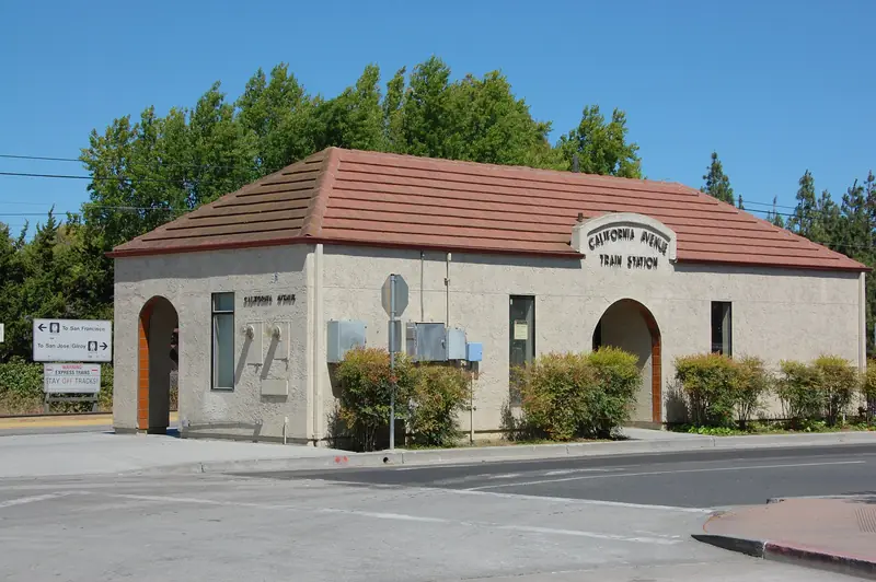
- California Avenue serves Midtown, the California Avenue shopping district and Stanford Research Park. Local and limited trains stop here. Express trains pass through.
- Stanford is a small platform by Stanford Stadium that has opened only on football game days. Caltrain said it would not be open for the 2026 season and directs fans to Palo Alto station instead.
Both Palo Alto stations are in Zone 3. Fares are set by the number of zones you cross. At the time of writing a one zone adult ride cost $4.00 and a three zone ride to San Francisco cost $8.50. Caltrain has announced higher fares from January 1, 2027, so see our Caltrain guide for the current table. Day passes cost twice the one way fare. Youth riders pay $1 one way for any distance. Check the official fares page before you ride.

How to pay
The Bay Area's transit card is called Clipper. You can buy a physical card at station ticket machines or add a Clipper card to Apple Pay or Google Pay. You can also simply tap a contactless debit or credit card. Whatever you use, tap on at the platform validator before you board and tap off when you get off. Since January 1, 2026 every payment method pays the same fare. Ticket machines also sell one way tickets and day passes.
Schedules and service
Caltrain runs a repeating clockface schedule, so trains leave at the same minutes past each hour. Weekday service is more frequent than weekends. Bikes ride in designated cars. A regional transit funding measure is on the November 2026 ballot. Caltrain has said it would need deep cuts if new funding does not come through, so check the service status page for the current timetable.
The Stanford Marguerite shuttle
Stanford's Marguerite shuttle is free and open to everyone, not only students. All buses are wheelchair accessible and carry bike racks. The main lines run Monday through Friday and skip university holidays. Most visitor-friendly lines start at the Palo Alto Transit Center beside the Caltrain station.
| Line | Where it goes | Useful for |
|---|---|---|
| P | Transit Center to the campus Oval via Palm Drive | The Main Quad and Memorial Church |
| X and Y | Loops around the main campus from the Transit Center | Museums, Hoover Tower and campus buildings |
| MC | Transit Center to the medical center via Welch Road | Stanford Hospital visits |
| S | Transit Center along Sand Hill Road to the Rosewood hotel | Sand Hill Road and west Menlo Park |
| CAX | California Avenue Caltrain to Stanford Research Park | Research Park offices |
| Shopping Express | Transit Center, campus and San Antonio Shopping Center | Weekend errands |
Routes and times change by quarter. Use the Marguerite lines and schedules page or the live map app to see where buses are. For more on the campus itself see visiting Stanford.
VTA and SamTrans buses
Palo Alto sits on the line between two county bus systems. VTA serves Santa Clara County to the south and SamTrans serves San Mateo County to the north. Both meet at the Palo Alto Transit Center.
- VTA Rapid 522 runs limited stop service down El Camino Real to San Jose and on to Eastridge. Stops are about a mile apart.
- VTA Route 22 covers the same El Camino corridor with local stops.
- SamTrans ECR runs north on El Camino Real through Menlo Park, Redwood City and San Mateo all the way to Daly City BART. It runs seven days a week.
Clipper and contactless cards work on both systems. The buses are slower than Caltrain but handy for stops along El Camino Real. Check vta.org and samtrans.com for fares and times.
Biking and walking
The city is flat and has a long network of bike boulevards, quiet residential streets where bikes get priority. Bryant Street is the best known and runs parallel to busier Middlefield Road. Stanford has thousands of bike racks and many students get around campus by bike.
There is no public bike share in Palo Alto at the moment. The city studied shared bikes and scooters, but that project was paused in September 2026. Your options are to bring your own bike on Caltrain or rent one. A few local shops rent bikes by the day. You can also search bike rentals near Palo Alto online before you go. Walking works well too. Downtown to the Main Quad is about a mile on foot via Palm Drive.
Rideshare, taxis and robotaxis
Uber and Lyft both operate in Palo Alto and at all three Bay Area airports. Waymo's driverless cars also serve the city. Palo Alto joined Waymo's Silicon Valley service area in 2025 and later expansions added freeway trips and pickups at San Jose airport. Book through the Waymo app. The app shows the exact service boundary, which matters if your destination is on the Stanford campus or in the hills.
The city's own on-demand shuttle, Palo Alto Link, ended service on October 30, 2026. Seniors and riders with disabilities can look into programs from the Palo Alto Transportation Management Association and Avenidas instead.
Parking downtown and on campus
Downtown and California Avenue
Short visits are free. The city allows two hours on the street and in surface lots and three hours in most garages unless signs say otherwise. Large garages downtown include the Civic Center garage plus the garages at Bryant and Lytton, at High and Alma and at Webster and Cowper. On California Avenue the biggest is the garage at 350 Sherman Avenue. For a full day, buy a daily permit. It cost $25.70 at the time of writing and is sold at several garages and at City Hall. Rules are being updated, so read the city's visitor parking page before you go.
Driving an electric car? The city runs 121 public charging ports at garages, lots and a few city buildings. See our EV charging guide for locations and overnight rates.
Stanford campus
Stanford visitor parking is paid through ParkMobile. Find the zone number on the green signs where you park and pay by app, by phone or through the no-app zone option. Rates at the time of writing were $4.46 an hour or $35.68 a day, plus a small transaction fee. Check the Stanford visitor parking page for current rates and hours. On big event days, especially football, parking fills fast and the train is the better bet.
Renting a car
Most visitors rent at the airport, where choice and prices are best. You can compare airport rental cars or check more rental offers before you land. Stanford also has a Hertz branch in the Stock Farm Garage at 360 Oak Road and Zipcar car sharing on campus. A car is worth it for day trips to Half Moon Bay, the Santa Cruz Mountains or Foothills Nature Preserve, where transit does not reach.
Good to know
- Caltrain is the fastest way to reach San Francisco or San Jose from Palo Alto, often faster than driving at rush hour.
- Marguerite main lines do not run on weekends. Plan weekend campus visits on foot, by bike or by rideshare.
- Read parking signs carefully in residential permit districts. Anyone can park for two hours without a permit.
Sample trips
- Downtown to the Cantor Arts Center: walk 20 to 25 minutes up Palm Drive, or ride Marguerite Line P on a weekday. See our Cantor guide.
- Downtown to California Avenue: one Caltrain stop on a local or limited train, or about 1.8 to 2 miles on foot, a 35 to 45 minute walk. See our walking guide.
- Palo Alto to San Francisco: Caltrain express to Fourth and King. Express trains cover the full line from San Jose in about an hour, so Palo Alto is roughly 40 minutes out.
- Downtown to the Baylands: about 3 miles east on Embarcadero Road. Bike, drive or take a rideshare. Read our Baylands guide.
Commute guides
Living here and working somewhere else, or the other way around? These guides compare the main options for the most common daily trips to and from Palo Alto.
- Commuting to San Francisco
- Commuting to San Jose
- Commuting to Mountain View
- Commuting to Menlo Park
- Commuting to Cupertino
- Commuting to Stanford
- Commuting to Sunnyvale
- Commuting to Redwood City
- Commuting to the East Bay
In this section
Frequently asked questions
Is the Stanford Marguerite shuttle free for visitors?
Yes. Stanford says all Marguerite routes are free and open to the public. Most lines run on weekdays only and skip university holidays. Several lines start at the Palo Alto Transit Center next to the Caltrain station.
Which Caltrain station is closest to Stanford Stadium?
Use Palo Alto station. Caltrain said Stanford station would not be open for the 2026 football season. The walk from Palo Alto station along Palm Drive and Arboretum Road takes a little over 20 minutes.
Is parking free in downtown Palo Alto?
Short visits are free. City rules allow two hours on the street and in surface lots and three hours in most garages. For longer stays buy a daily permit, which cost $25.70 at the time of writing.
Does Waymo operate in Palo Alto?
Yes. Palo Alto is inside Waymo's Bay Area service area and the company has served the city since 2025. Book through the Waymo app. Coverage of the Stanford campus was not confirmed, so check the map in the app.
Does Palo Alto have bike share?
Not at the moment. The city's study of shared bikes and scooters was paused in September 2026. Visitors can rent from local bike shops or bring a bike on Caltrain.