On this page
Purisima Creek Redwoods is the closest big redwood canyon to Palo Alto on the ocean side of the ridge. The Midpeninsula Regional Open Space District, known as Midpen, manages 5,412 acres on the western slopes of the Santa Cruz Mountains above Half Moon Bay. Its centerpiece is Purisima Creek Canyon, with tall redwoods, a rushing creek and an understory of ferns, berries and wildflowers. The northern part of the preserve has wide views of the coast.
Our hiking guide gives it a short entry. This page goes deeper, with every entrance, the main trails as Midpen describes them, the rules and the logging history you can still see on the ground. It also helps you decide between the ridge and the coast, which is the main choice you make here.
Choose your side: ridge or coast
The preserve has two very different front doors. From Skyline Boulevard you start high in the forest and walk down, so the climb comes at the end. From Purisima Creek Road near Half Moon Bay you start at the bottom of the canyon and walk up beside the creek, so the hard part comes first and the return is easy.
| Entrance | Spaces | Best for |
|---|---|---|
| North Ridge Parking Area, Skyline Boulevard | 41 plus 2 accessible | Ridge views and routes down into the canyon |
| Redwood roadside parking, Skyline Boulevard | 11 plus 2 accessible | The accessible Redwood Trail |
| Purisima Creek Road Parking Area, coast side | 7 plus 1 accessible | The Purisima Creek Trail along the creek |
Getting there from Palo Alto
To Skyline Boulevard
The simplest route is Woodside Road, Highway 84, west from Interstate 280 through Woodside and up to Skyline Boulevard, Highway 35. Turn north. Midpen puts the Redwood roadside parking about 6 miles north of the Highway 84 junction and the North Ridge Parking Area about 8 miles north, both on the left. Coming from the north instead, the North Ridge lot is about 4.4 miles south of the Highway 92 junction on the right. Allow roughly 45 minutes from downtown Palo Alto. Our Woodside village guide covers a coffee or lunch stop on the way up.
To the coast side
Drive to Half Moon Bay, then head south on Highway 1 for about 4.3 miles from the Highway 92 junction and turn left on Verde Road. After a quarter mile, continue straight onto Purisima Creek Road and follow it about 3.7 miles to the lot. Midpen calls parking here extremely limited, with 7 spaces plus 1 accessible space. It strictly enforces no-parking areas, so arrive early or have a backup plan. Pair it with lunch in town using our Half Moon Bay day trip.
The main trails
Redwood Trail
Just off Skyline Boulevard, this flat trail winds 0.25 mile through tall redwoods. Midpen says it suits visitors of all physical abilities, with wheelchair-accessible picnic tables and a restroom along the way. A grant from Peninsula Open Space Trust paid for it. It is the best choice with small children, older relatives or a wheelchair. Our accessible travel guide lists other options.
From Skyline into the canyon
The North Ridge Parking Area is the starting point for routes down into Purisima Canyon. Midpen highlights three. The upper parts of the Harkins Ridge Trail and the Soda Gulch Trail give superb views of the San Mateo coast and the Pacific. The Whittemore Gulch Trail drops steeply into the canyon and is popular with mountain bikers. Midpen says part of it also has fine views. Midpen's preserve page does not give one-way distances for these trails; use its downloadable map, which marks mileage between junctions. Remember that every step down is a step back up.
Purisima Creek Trail
This is the classic canyon walk from the coast side. Midpen describes an old logging road that passes an accessible restroom and climbs at a gentle grade for the first mile, with a few short pitches of 10 to 15 percent. It follows the creek and crosses it on several bridges, through redwood groves and open meadows with glimpses of the ocean. A short out-and-back on the first gentle mile makes an easy family walk.
Grabtown Gulch and Borden Hatch Mill loop
For a longer outing, Midpen describes a loop of nearly five miles on the Grabtown Gulch and Borden Hatch Mill trails. You can reach it from pullouts on Tunitas Creek Road or from the Purisima Creek Road lot by walking about a mile up the Purisima Creek Trail. Midpen says the remote trail lets you fully hear the sounds of the redwoods. Tunitas Creek Road pullouts are limited, so be ready with a plan B.

Reading the redwood forest
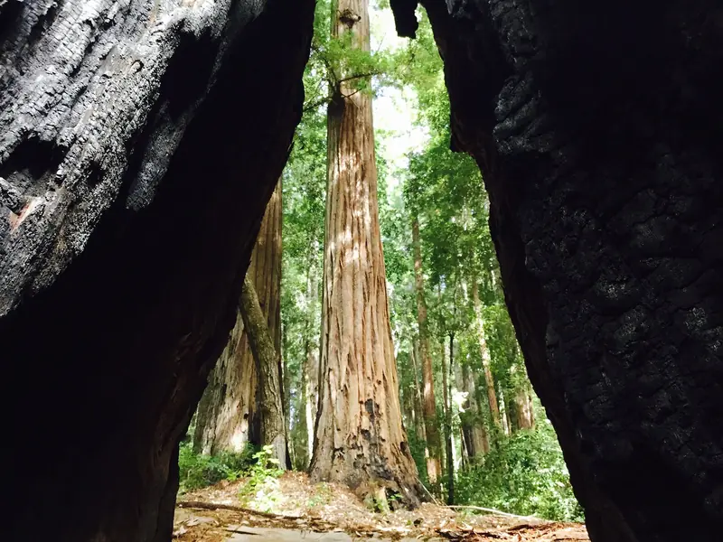
Midpen explains that coast redwoods grow only in a narrow band from southern Oregon to just south of Monterey. They are the tallest trees in the world, reaching up to 380 feet. The oldest known redwood lived about 2,200 years. Most trees at Purisima are about 100 years old, a second-growth forest. The original forest was logged from the late 1800s into the 1900s. The largest trees cut were probably close to 1,000 years old, with trunks 10 to 20 feet across. Look for their huge stumps along the Purisima Creek Trail.
Midpen counts seven recorded mill sites along the creek. Redwood from the canyon became shingles for San Francisco after the Gold Rush and lumber for Half Moon Bay, including a flume on Montara Mountain. Along the Purisima Creek Trail you can still spot clearings where the sawmills stood. By the early 1900s, every tree that was not too small, too twisted or too hard to reach was gone. The preserve itself began with a $2 million gift from Save the Redwoods League. Our redwood forests guide compares Purisima with Big Basin and other groves.
Rules for dogs, bikes and horses
- Dogs: not allowed. Service dogs are accommodated.
- Bikes: designated trails only, marked on the map. Helmets are required. The speed limit is 15 mph, or 5 mph when passing. E-bikes are not allowed on most Midpen trails. Midpen's map notes that the Whittemore Gulch Trail closes seasonally to bicyclists and equestrians.
- Horses: designated trails only. Helmets are recommended. Everyone yields to riders.
- Water: no swimming, wading or water contact in the creek.
- Other rules: no drones, fires, smoking or weapons. No camping. Pack out all trash.
Seasonal notes
The coast side is often foggy and cool in summer, which makes the canyon a good escape on hot days inland. Winter rain brings the creek up and the ferns back to bright green, along with mud and seasonal bike closures. Fall can be the clearest time for ocean views from the ridge trails. Midpen's guided walks follow the seasons too. Its calendar lists Return to the Green on November 18, Counting Banana Slugs on November 21, 2026, Fungal Fun on January 9 and February 6, 2027 and a Lichen Deep Dive on January 27, 2027. Midpen has also published a story headlined that all trails in the preserve are open. Check the preserve page for current conditions.
Safety
If you start on Skyline, the climb comes at the end of the day, so start early and turn around before you are tired. Bring water, since none is available on the trails; Midpen recommends two quarts per person for every two hours. Cell service is sporadic in the canyon.
- Mountain lions are a natural part of this region and occasionally seen. Do not run. Keep children close, face the lion, stand tall and make noise, then leave and warn others.
- Ticks are present and may carry disease. Use repellent, stay in the middle of the trail and check yourself when you get home, as the City of Palo Alto's tick checklist advises.
- Poison oak grows along many trail edges in the canyon. Its oil stays potent on the bare stems in winter.
- Emergencies: call 911. For non-emergencies Midpen's office is 650-691-1200.
For a second redwood stop on the way home, Huddart Park in Woodside is a San Mateo County park with its own second-growth redwoods.
Frequently asked questions
What is the easiest hike at Purisima Creek Redwoods?
The Redwood Trail just off Skyline Boulevard. Midpen describes it as a flat 0.25-mile route through tall redwoods, suitable for visitors of all abilities, with wheelchair-accessible picnic tables and a restroom. Park in the Redwood roadside parking area.
Where should I park for Purisima Creek Redwoods?
On the ridge, the North Ridge Parking Area has 41 spaces plus 2 accessible and the Redwood roadside area has 11 plus 2 accessible. On the coast side, the Purisima Creek Road lot has only 7 spaces plus 1 accessible and Midpen says no-parking zones are strictly enforced.
Are dogs allowed at Purisima Creek Redwoods?
No. Midpen does not allow dogs in Purisima Creek Redwoods Preserve. Service dogs are accommodated under the Americans with Disabilities Act.
Are the redwoods at Purisima old growth?
No. Midpen says most trees in the preserve are about 100 years old, a second-growth forest that regrew after logging in the late 1800s and early 1900s. Large stumps along the Purisima Creek Trail show where trees close to 1,000 years old once stood.
Can you mountain bike at Purisima Creek Redwoods?
Yes, on designated trails. Helmets are required and the speed limit is 15 mph, or 5 mph when passing. Midpen notes that Whittemore Gulch is popular with mountain bikers. Its map says that trail closes seasonally to bicyclists and equestrians.