On this page
Downtown Palo Alto is where the city started and where most visitors spend their time. It is compact. University Avenue runs straight from the train station toward Middlefield Road and almost everything worth seeing lies within a few blocks of it. In one walk you can pass a thousand-year-old redwood, a 1925 movie palace, a block of Spanish Revival storefronts and the offices where famous startups once rented their first desks.
This guide covers the main sights, how the streets are organized, where the shops and restaurants cluster, how to get in and out by train and the basics of parking. It is written for visitors and for new residents trying to get their bearings.
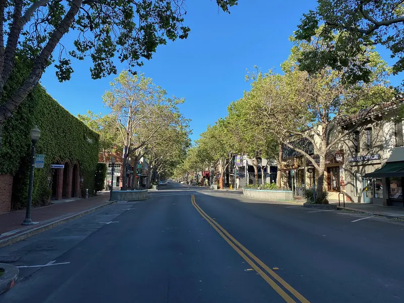

How downtown is laid out
Timothy Hopkins laid out the townsite of University Park in 1887 to serve the new Stanford University. Its grid still shapes downtown. University Avenue is the spine. It begins at the Caltrain station, passes under the tracks and Alma Street and runs northeast past the old commercial blocks. On the Stanford side of the tracks the same road crosses El Camino Real and becomes Palm Drive, the long palm-lined approach to the Main Quad.
The cross streets are named for writers and scientists. Heading away from the station you reach High, Emerson, Ramona, Bryant, Waverley, Kipling, Cowper, Tasso and Webster. Lytton Avenue runs parallel one block to the north. Hamilton Avenue runs one block to the south and carries City Hall. Beyond them the blocks turn residential quickly. North of downtown is the Downtown North neighborhood, which runs to San Francisquito Creek. South of it, past Forest and Homer avenues, lie Professorville and the houses of Palo Alto's first professors.
Distances are short. Walking from the station to Webster Street takes about 15 minutes at an easy pace. Most of the restaurants and shops sit between High Street and Webster Street. The parallel blocks of Hamilton and Lytton add plenty more.
University Avenue
University Avenue has been the town's main street since the 1890s. Early photos show a dirt road with a few wooden storefronts. Today it is a line of low buildings from the 1920s through the 1960s mixed with newer office blocks. The ground floors hold restaurants, cafes, clothing and home goods shops, banks and a steady rotation of tech showrooms. Upper floors are mostly offices.
The best way to see it is on foot in the late afternoon, when office workers spill out and outdoor tables fill up. Look up as you walk. Many buildings carry dates, tile details or decorative cornices that are easy to miss at street level. For a sense of how much has changed, compare the scene with the 1894 photo of University Avenue in our history of Palo Alto.
Lytton Plaza
Lytton Plaza sits at the corner of University Avenue and Emerson Street. Banker Bart Lytton built it in 1964 across the street from his Lytton Savings Bank and dedicated it to the use and enjoyment of the people of Palo Alto. It became the town's open-air stage almost at once. In July 1970 police arrested 263 people there after amplified music ran past an 11 p.m. curfew, an episode that is still part of local lore. The city later bought the plaza. A redesigned version opened in 2009 and it remains a meeting point, a lunch spot and a place for rallies and street musicians.
Ramona Street and Birge Clark
Walk one block south on Ramona Street toward Hamilton Avenue and the architecture changes. The 500 block of Ramona is the Ramona Street Architectural District, listed on the National Register of Historic Places in 1986. Its buildings share a Spanish Colonial and early California look. Expect arched openings, wrought iron, red tile roofs at different heights and small courtyards tucked behind the storefronts.
Two designers shaped the block. Pedro de Lemos, a craftsman, graphic artist and curator of the Stanford museum, built the Gotham Shop at 520 Ramona in 1925 around an old oak tree he wanted to save. He also designed the 1938 office building at 533 to 539 Ramona with its recessed arched entrance and inner patio. Birge Clark, the most prolific Palo Alto architect of the twentieth century, designed much of the rest of the block. His multistory Medico-Dental Building at Hamilton and Ramona went up in 1928 (some sources say 1927).
Clark was the son of Stanford art professor Arthur Bridgman Clark and he shaped the look of the whole city. His other work includes the 1932 Palo Alto post office and the Lucie Stern Community Center on Middlefield Road. Across Ramona Street at Hamilton Avenue stands the Cardinal Hotel, designed by W. H. Weeks as Palo Alto's first hotel that was not wood frame.
The Stanford Theatre
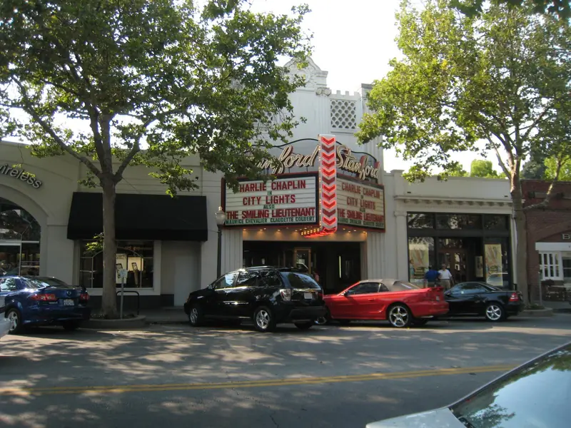

The Stanford Theatre at 221 University Avenue is downtown's best-loved landmark. It opened in 1925 to designs by the San Francisco firm Weeks and Day. Inside, the lobby mixes Persian and Moorish details with crystal chandeliers. The auditorium seats close to 1,500 people.
Like many old movie houses it fell on hard times. In 1987 David Woodley Packard organized a Fred Astaire festival there. The turnout persuaded the Packard family to save the building. The David and Lucile Packard Foundation bought and restored it and the theater reopened in 1989 with The Wizard of Oz. Today it shows classic Hollywood films, usually as double features on 35mm film. A Mighty Wurlitzer organ rises from the pit to play before and between screenings. Check the Stanford Theatre website for the current calendar.
The Caltrain station and El Palo Alto
The Palo Alto Caltrain station at 95 University Avenue is the western anchor of downtown. The current depot opened on January 25, 1941. Southern Pacific architect John H. Christie designed it in the Streamline Moderne style, inspired by the railroad's sleek Daylight trains. It was listed on the National Register of Historic Places in 1996. Caltrain has run electric trains on the line since 2024.
The station is also a transit hub. VTA and SamTrans buses stop here, as do city shuttles and the free Stanford Marguerite shuttle to campus. Check Caltrain for current schedules. Our getting to Palo Alto guide covers trips from San Francisco, San Jose and the airports.
A short walk north along Alma Street brings you to El Palo Alto, the coast redwood that gave the city its name. It stands beside the tracks in tiny El Palo Alto Park at Alma Street and Palo Alto Avenue, right where San Francisquito Creek marks the county line. Arborists put its age at roughly 1,080 years.
Shopping and dining streets
Downtown has the densest mix of restaurants in the city. University Avenue carries the most foot traffic. The quieter side streets are often better for a relaxed meal.
- University Avenue between High and Webster streets has the most restaurants, cafes and shops.
- Emerson Street and Ramona Street have smaller restaurants and bars. Ramona's courtyards make good lunch stops.
- Hamilton Avenue runs past City Hall and has restaurants and cafes of its own.
- Bryant Street is a designated bike route and is calmer than University Avenue.
For bigger brand-name shopping, Stanford Shopping Center is across El Camino Real, about a 15 minute walk from the station or a short shuttle ride. Our food and drink guide and coffee guide name specific places.
Parking rules in general terms
Downtown parking is a frequent local debate and the rules change from time to time. The basics stay fairly steady.
- Public garages and lots. The city runs about 20 public garages and lots downtown. They include garages on Bryant Street, High Street and Webster Street and the garage under City Hall at 250 Hamilton Avenue.
- Free but time limited. Short visits are generally free, with posted time limits on streets and in many garage areas. The city also uses color-coded parking zones downtown, so read each sign carefully.
- Permits for longer stays. Employees, employers and visitors who need all-day parking can buy permits from the city.
- Residential permit areas. Blocks around downtown are covered by a residential parking permit program, so long-term parking on neighborhood streets is restricted.
- EV charging. Several city garages have chargers.
Always read the signs and check the City of Palo Alto parking page for current limits, permit prices and any paid parking before you go. If you are coming from the Peninsula or San Francisco, the train is often easier than the car.
Tech offices on University Avenue
Downtown Palo Alto has been startup territory for decades. The upper floors along University Avenue and the side streets are full of company offices, venture firms and coworking spaces. The most famous address is 165 University Avenue, nicknamed the lucky building after early versions of Google and PayPal worked there. Facebook also grew up in downtown offices after moving to Palo Alto in 2004.
The pattern continues. Young companies rent small suites near the station, grow and then move to bigger campuses in Stanford Research Park or elsewhere in the valley. For a walking list of landmark addresses see our famous tech addresses page. For desks and meeting rooms see coworking and office space.
A simple downtown walk
Start at El Palo Alto Park, then walk south to the Caltrain station to see the 1941 depot. Follow University Avenue to Lytton Plaza at Emerson Street. Turn right onto Ramona Street and walk the 500 block to Hamilton Avenue. Continue along Hamilton past City Hall, then swing back up to University Avenue to see the Stanford Theatre marquee. From there it is a few blocks south to Professorville and the HP Garage at 367 Addison Avenue. Allow about two hours with stops. Many visitors prefer a guided outing that adds Stanford and the big tech campuses, so you might browse Silicon Valley tours. To stay close to the station and the restaurants, compare hotels near University Avenue.
Frequently asked questions
Is downtown Palo Alto walkable?
Yes. The core runs about half a mile along University Avenue from the Caltrain station to Webster Street, with parallel blocks on Hamilton Avenue and Lytton Avenue. Most restaurants, shops, the Stanford Theatre and City Hall are within a ten minute walk of each other.
Where do I park in downtown Palo Alto?
The city runs several public garages and lots downtown, including garages on Bryant Street, High Street, Webster Street and under City Hall. Free parking is time limited and longer stays need a permit. Rules change, so check the City of Palo Alto parking page before you go.
What movies does the Stanford Theatre show?
The Stanford Theatre at 221 University Avenue specializes in classic Hollywood films, often as double features on 35mm film. A Wurlitzer organ plays before and between shows. It was restored by the David and Lucile Packard Foundation and reopened in 1989.
How far is downtown Palo Alto from Stanford?
The Main Quad is a little over a mile from the Palo Alto Caltrain station. University Avenue becomes Palm Drive once it crosses El Camino Real. The free Stanford Marguerite shuttle runs from the station to campus.
What is the Ramona Street Architectural District?
It is the 500 block of Ramona Street between University and Hamilton avenues, listed on the National Register of Historic Places in 1986. The buildings share a Spanish Colonial and early California look with arches, tile roofs, wrought iron and courtyards.