On this page
Cooley Landing is a small park with a big view. It sits on a point of land at the very end of Bay Road in East Palo Alto, with San Francisco Bay on three sides and salt marsh all around. On a clear morning you can see the East Bay hills, the Dumbarton Bridge and the long shoreline curving toward Palo Alto. On a windy afternoon you can watch whitecaps roll across the shallows.
It is also one of the best comeback stories on the Peninsula. For most of the twentieth century the point was a dump where garbage was burned in the open. Today it is about nine acres of trails, native plants, picnic spots and an education center built from an old boatworks building. Our East Palo Alto guide covers the city as a whole. This page goes deeper on the landing itself.
History of the point
Ohlone shoreline and an early port
Long before there was a wharf, Ohlone people fished and gathered along this shoreline. The bay margins held shellfish, waterfowl and tule reeds. Our page on the Ohlone and the land before 1769 explains how they lived along these marshes.
In 1849, during the gold rush, Isaiah Churchill Woods tried to turn the area into a major shipping town. He named it Ravenswood. The point served as a landing where redwood lumber and other goods were loaded onto boats bound up the bay. Palo Alto Online's account of the 2016 dedication calls the early wharf Martin's Landing, which shows how loosely names were used in those years. Woods' venture failed.
Lester Cooley and the brickworks
In 1868 Lester Phillip Cooley bought the wharf and the land around it. He leased part of it to a brick factory, Hunter and Schakleford. The brickworks left in 1884 and the land around the landing reverted to ranching. Cooley's name outlasted all of it.
The dump years
In the twentieth century the point became a county dump. Refuse was burned in the open for decades. The soil filled with mercury, arsenic, lead, PCBs and other contaminants. A U.S. EPA release from 2012 called it an eighty-year-old former toxic dump. An old dredge was left on the site and a boat repair business operated there for many years. One of its buildings later became the heart of the education center.
Meanwhile, conservation changed the land around the point. The Midpeninsula Regional Open Space District bought the marsh on either side, which became the Ravenswood Open Space Preserve. The Packard Foundation and the Peninsula Open Space Trust later helped secure the final strip. In 1998 East Palo Alto was named one of the U.S. EPA's brownfields showcase communities, which brought federal attention and money to sites like this one.
From dump to park
The city built the park in phases, mostly with grants. The timeline, as published by the city and the open space district, runs like this:
| When | What happened |
|---|---|
| Late 2011 | Cleanup broke ground. The whole peninsula was capped with two feet of clean fill. |
| March 2012 | The state awarded $5 million in Proposition 84 park funds for later phases. |
| July 2012 | Phase I opened: trails, parking, benches and a picnic area. |
| September 2013 to February 2014 | The park closed for Phase II: utilities, road work and native planting. |
| September 2015 | The Education Center was completed. |
| April 16, 2016 | The Education Center and park were formally dedicated before a crowd of nearly 300. |
| July 2019 | Phases IV and V finished: outdoor classroom, picnic areas, interpretive signs, trails and native plants. |
The open space district also contributed $1,256,300 in Measure AA funds and pays for ongoing plant restoration through a partnership with Grassroots Ecology. Funders over the years have included the U.S. EPA, the state Department of Toxic Substances Control, CalRecycle, the National Fish and Wildlife Foundation, the Packard Foundation and the San Francisco Foundation. The 2012 EPA release noted that the park would raise East Palo Alto's total parkland by about 72 percent, a sign of how little open space the city had.
The Cooley Landing Education Center
The Education Center is a single-story building of roughly 3,000 square feet on the water's edge. The 2012 EPA release described the plan as a renovation of the historic boatworks building on the site. FOG Studio designed it after eight community meetings. Large windows look straight out over the bay.
Inside there is a multipurpose room with projection equipment, a warming kitchen, restrooms and space for exhibits on East Palo Alto's history and culture. The city uses it for partner-run education programs and community meetings and rents it for some private events. The city has said it is looking for a long-term partner to run programs there, so public hours inside the building vary. The grounds stay open even when the building is closed.
What you will see
The park is compact. A loop around the point takes most people 20 to 30 minutes at an easy pace, longer if you stop to read the signs or watch birds. Expect:
- Open bay views to the north and east, with the Dumbarton Bridge and the East Bay hills on the horizon.
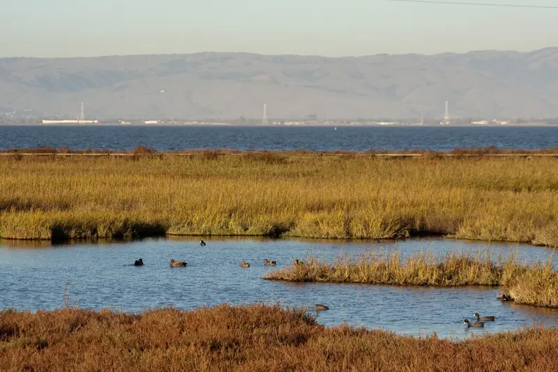
- Salt marsh on the landward sides, with pickleweed, tidal channels and mudflats that change hour by hour with the tide.
- Interpretive signs on the site's Ohlone, shipping, dump and cleanup history.
- An outdoor classroom and picnic tables near the Education Center.
- Native plantings on the capped ground, maintained with volunteer help.
Birds
The surrounding marsh is prime habitat. Great egrets, snowy egrets and great blue herons hunt the channels. Shorebirds crowd the mudflats as the tide drops. Ducks raft offshore in winter. The open space district notes that the Palo Alto Baylands, just to the south, has the highest concentration of the endangered Ridgway's rail in the world. Rails are shy, so your best chance is a quiet visit near high tide with binoculars. Our birdwatching guide covers the best seasons and nearby spots.

Connecting to the Bay Trail and Ravenswood Preserve
The Midpeninsula Regional Open Space District owns the Ravenswood Open Space Preserve on either side of the point and gives the city an easement for the road in. The preserve has a flat, easy levee trail around the marsh. That trail links to the San Francisco Bay Trail, which lets you turn a visit to Cooley Landing into a longer walk or ride.
- South on the Bay Trail, you cross San Francisquito Creek to the Palo Alto Baylands and the hills of Byxbee Park.
- North, the trail heads toward Menlo Park and Bedwell Bayfront Park, another former landfill turned bayfront park.
The preserve keeps its own sunrise to sunset hours, while the district keeps the commuter section of Bay Trail between University Avenue and Bay Road open longer. Check the district's preserve page for current trail conditions, since levee work sometimes closes sections.
Getting there from Palo Alto
- By car: Take University Avenue northeast from downtown Palo Alto, across the creek and over Highway 101. Turn right on Bay Road and follow it east to the end. The last stretch is the park's access road. Parking is limited, so arrive early on sunny weekends.
- By bike: The Bay Trail from the Palo Alto Baylands is the scenic route and mostly car-free. Our biking guide explains how to reach it. Riding Bay Road from University Avenue also works but has more traffic.
- By bus: SamTrans serves East Palo Alto, though no route runs to the end of Bay Road. Expect a walk of a mile or more from the nearest stop.
If you are coming from out of town and want a bike for the day, you can compare bike rentals in the area.
Tips for a good visit
Good to know
- The city lists hours as sunrise to sunset. Watch the time on sunset walks so you are out before the gate closes.
- Wind off the bay picks up most afternoons. Bring a layer even in summer.
- There is little shade. Bring water and sun protection.
- Stay on paths. The capped soil and the marsh plants both depend on it.
- Check the city's Cooley Landing page before a group visit or event booking.
Cooley Landing pairs well with a meal on University Avenue. Our guide to where to eat in East Palo Alto lists taquerias and other spots a few minutes away. For more flat bay walks, see our picnic spots and the Bay Trail guide.
Frequently asked questions
What are Cooley Landing's hours?
The City of East Palo Alto lists the park as open from sunrise to sunset. It is free and open to everyone during those hours. The park itself cannot be reserved, but the Education Center building can be booked for events through the city.
Can you walk from Cooley Landing to the Palo Alto Baylands?
Yes, with some planning. Cooley Landing sits beside the Ravenswood Open Space Preserve, whose levee trail links to the San Francisco Bay Trail. From there the Bay Trail runs south across San Francisquito Creek to the Palo Alto Baylands and north toward Bedwell Bayfront Park in Menlo Park.
Why was Cooley Landing a toxic site?
For decades the point was used as a dump where refuse was burned in the open. The soil ended up contaminated with metals and PCBs. Cleanup started in late 2011 and capped the whole peninsula with two feet of clean fill before the park opened in 2012.
Who was Cooley Landing named after?
It is named for Lester Phillip Cooley, who bought the wharf and land in 1868 after Isaiah Churchill Woods' plans for a shipping town called Ravenswood collapsed. Cooley leased part of the land to a brick factory. The name stuck long after the wharf disappeared.
Are dogs allowed at Cooley Landing?
The city's park page does not spell out a dog rule. The neighboring Ravenswood Open Space Preserve has its own rules set by the Midpeninsula Regional Open Space District, which you should check before you bring a dog. Keep any dog leashed and out of the marsh, which shelters protected birds.