On this page
Palo Alto's Spanish name is not decoration. It comes from a single week in November 1769 when soldiers of the Portolá expedition rested beside San Francisquito Creek. What followed over the next eight decades set the property lines, place names and even some street routes of the modern city.
This page covers that period in order: the expedition, the mission that claimed the land, the Mexican ranchos and the families who ran them and the American takeover that stripped most of those families of their holdings. The story before 1769 is on our page about the Ohlone. The later rise of Mayfield and Palo Alto is on the Mayfield and founding pages.
The Portolá expedition reaches the creek
In 1769 Spain sent a land expedition north from San Diego under Gaspar de Portolá, the governor of the Californias. Its goal was Monterey Bay, which Sebastián Vizcaíno had described in 1602. The party walked past Monterey without recognizing it and kept going north.
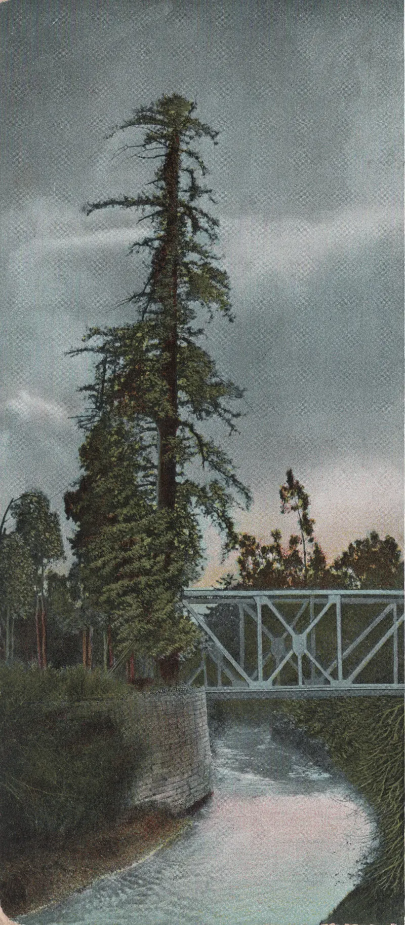
On November 2, 1769, members of the party saw San Francisco Bay from the ridge now known as Sweeney Ridge above Pacifica. They were the first Europeans on record to see it. Portolá then led the group south and east around the bay. From November 6 to 11 the expedition camped by San Francisquito Creek, near a towering redwood that stood out across the flat valley. The soldiers called it El Palo Alto, the tall stick.
The camp was a turning point. Scouts sent ahead found the bay too large to get around easily, supplies were short and men were sick. The expedition turned back toward San Diego from here.
Which tree?
Historians do not agree that today's El Palo Alto is the exact tree the soldiers saw. Wikipedia's account, drawing on local historians, notes that the evidence points to the tree in Pedro Font's 1776 drawing being a different one. Steve Staiger of the Palo Alto Historical Association has suggested the camp may have been under a tree farther downstream. The surviving redwood, about 1,080 years old, sits on the Palo Alto side of the creek in El Palo Alto Park. Our page on El Palo Alto covers its history and how to visit.
The state marks the camp with California Historical Landmark No. 2, "Portolá Journey's End," registered on June 1, 1932. Its plaque stands just across the creek in Menlo Park, near Alma Street and East Creek Drive. A second plaque there notes that Father Francisco Palóu erected a cross at the spot in 1774 and that Font's 1776 map showed the tree.

Mission Santa Clara claims the land
Spain followed the expedition with missions and a presidio. Mission San Francisco de Asís was founded in 1776. Father Junípero Serra founded Mission Santa Clara de Asís in 1777 near the Guadalupe River, about 15 miles southeast of El Palo Alto. The Pueblo de San José was established the same year.
Mission Santa Clara's grazing lands stretched across most of what is now Palo Alto and Stanford. Cattle, sheep and horses spread over the grasslands that Ohlone families had burned and harvested for generations. Ohlone people from the area were baptized at the mission and lived and labored there. Our Ohlone history page explains what that meant for them.
San Francisquito Creek later became a political boundary as well. Today it marks the line between Santa Clara and San Mateo counties, with Palo Alto on one bank and Menlo Park and East Palo Alto on the other.
Mexican independence and the ranchos
Mexico won independence from Spain in 1821. In the 1830s the new government secularized the missions and opened their huge pastures to private grants. Governors gave out large ranchos to Californio families and to soldiers who had served at the presidios. Three grants covered most of the future Palo Alto and Stanford.
| Rancho | Granted | Grantee | Size | Today |
|---|---|---|---|---|
| Rancho San Francisquito | 1839 | Antonio Buelna | About 1,471 acres | Northern part of the Stanford campus |
| Rancho Rinconada del Arroyo de San Francisquito | 1841 | María Antonia Mesa | About 2,230 acres | Downtown Palo Alto and parts of Menlo Park |
| Rancho Rincón de San Francisquito | 1841 | José Peña | 8,418 acres | South Palo Alto, Barron Park and southern Stanford |
Acreage figures come from the grant and patent records summarized by Wikipedia and the Palo Alto History Museum. Rancho boundaries were described by landmarks like creek bends and oaks, so modern equivalents are approximate.
Rancho San Francisquito
Governor Juan Alvarado granted this rancho on the southwest side of the creek to Antonio Buelna in 1839. Buelna died in 1842 and his widow, María Concepción Valencia, kept the claim. In the 1850s squatters settled on the land. George Gordon bought out both the squatters and the Buelna heirs in 1863 and named his estate Mayfield Grange. In 1876 Leland Stanford bought 650 acres of it from Gordon's heirs. That purchase became the core of the Palo Alto Stock Farm and later the university.
Rancho Rinconada del Arroyo de San Francisquito
The name means the corner at the bend of San Francisquito Creek. María Antonia Mesa was the widow of Rafael Soto. The couple had settled near the creek in 1835, close to today's Newell and Middlefield roads. They sold goods to travelers. Rafael died in 1839 and Governor Alvarado granted María Antonia the rancho in 1841. The City of Palo Alto's history credits the Soto family and their relatives by marriage, the Greers, with settling it. Greer Road in north Palo Alto carries that name.
When the Soto claim came before the U.S. Land Commission in 1852, it was rejected because neither the grant nor its map described the land. The family promised half of the rancho to Thomas Seale if he could win confirmation. A district court confirmed the grant in 1855. In 1887 Seale's family sold 697 acres to Timothy Hopkins, who laid out the new town of University Park on it. The full story is on our founding of Palo Alto page.
Secundino Robles and Rancho Santa Rita
The largest grant, Rancho Rincón de San Francisquito, began with José Peña, an artilleryman at the San Francisco presidio. In 1822 Mission Santa Clara allowed him to occupy one square league of its pasture. In 1841 Governor Alvarado granted him two square leagues.
In 1847 Peña sold most of the rancho to the brothers Secundino and Teodoro Robles. Some histories, including Wikipedia's Palo Alto article, give the year as 1849. The Robles family renamed the property Rancho Santa Rita, according to a 2021 E Clampus Vitus plaque at the Santa Clara Mission Cemetery where Secundino and his wife are buried.
Secundino Robles was a well-known figure. The same plaque says he found an Ohlone cinnabar mine at New Almaden as a boy in 1824 and served as mayordomo of Mission Santa Clara in the 1840s. He married María Antonia García in 1835 and they had 29 children. Sources disagree on his birth year. The plaque gives about 1811, Wikipedia gives 1813 and the Palo Alto History Museum gives 1830.
The family's hacienda became a social center for the area, according to the Palo Alto History Museum. It stood about three and a half miles south of Mayfield, across the railroad tracks near the end of today's San Antonio Road. The 1906 earthquake ruined the adobe. A plaque at Alma Street and Ferne Avenue marks the site. Robles Park on Park Boulevard carries the family name. It was called Mayfield Park until 1968.
Juana Briones
Another Californio landholder shaped south Palo Alto. In 1844 Juana Briones de Miranda, a businesswoman and healer from San Francisco, bought Rancho La Purísima Concepción, about 4,439 acres reaching into today's Los Altos Hills. Her home on what is now Old Adobe Road became California Historical Landmark No. 524. The house was demolished in 2011 after a long court fight. A state plaque marks the site.
The American takeover
The United States went to war with Mexico in 1846. In January 1847 Californio rancheros and U.S. forces fought a skirmish known as the Battle of Santa Clara. The Robles memorial plaque credits Secundino with a leadership role in it, in protest of the seizure of Californio horses and property. The Treaty of Guadalupe Hidalgo, signed February 2, 1848, ceded California to the United States. California became a state on September 9, 1850.
The treaty promised that property rights would be respected. The Land Act of 1851 then required every grant holder to prove title before a federal commission, often over many years. Lawyers' fees, surveys and appeals drained the ranchos. Squatters moved onto disputed land. Owners sold parcels to pay debts.
- The Robles brothers filed their claim in 1852. They received their patent in 1868.
- In 1853 they sold 250 acres to Elisha Oscar Crosby, who named it Mayfield Farm. That land is now Barron Park and the area around Matadero Creek.
- Secundino traded 500 acres to Jeremiah Clarke for a span of horses and a buggy, according to Wikipedia's rancho history.
- By 1863 court action had cut the Robles claim to 6,981 acres.
- Leland Stanford bought much of the remaining land in 1882.
Secundino Robles died in 1890. The 2021 plaque says the family could not afford headstones. It was placed partly to answer that injustice.
What remains today
Almost nothing from this era stands above ground in Palo Alto, but its outlines are everywhere once you know where to look:
- El Palo Alto on San Francisquito Creek, the tree that named everything after it.
- San Francisquito Creek itself, now the county line.
- The Robles adobe site plaque at Alma Street and Ferne Avenue and Robles Park nearby in south Palo Alto.
- The Juana Briones plaque on Old Adobe Road in the Palo Alto foothills.
- Street names such as Greer Road and San Antonio Road, along with the names of the creeks.
To see a mission of this era, drive about 15 miles south to Mission Santa Clara on the Santa Clara University campus. The current church is a twentieth century reconstruction, but the site continues the mission founded in 1777. Visitors who want context from a guide can look for a Bay Area history tour.
The next chapter belongs to Mayfield, the American town that grew up on old Robles land. Read about it on our Mayfield page, or jump ahead with the Palo Alto timeline.
Frequently asked questions
Did Portolá really camp under El Palo Alto?
The expedition camped beside San Francisquito Creek from November 6 to 11, 1769, near a tall redwood. Historians still debate whether that tree is today's El Palo Alto or one a little downstream. The name stuck either way.
What ranchos covered Palo Alto?
Three Mexican land grants covered most of today's Palo Alto and Stanford. Rancho Rinconada del Arroyo de San Francisquito covered the north including downtown. Rancho Rincón de San Francisquito covered the south. Rancho San Francisquito covered much of the northern Stanford campus.
Who was Secundino Robles?
Secundino Robles was a Californio ranchero who, with his brother Teodoro, bought Rancho Rincón de San Francisquito in 1847. The family renamed it Rancho Santa Rita. Their hacienda near today's San Antonio Road was a social center until the 1906 earthquake ruined it.
Where can I see Spanish and Mexican era sites in Palo Alto?
Little survives above ground. You can visit El Palo Alto on San Francisquito Creek, the Robles adobe site plaque near Alma Street and Ferne Avenue and the plaque for Juana Briones's home site on Old Adobe Road. Mission Santa Clara, rebuilt on the Santa Clara University campus, is a short drive south.