On this page
North Palo Alto has the old shingled houses and the famous addresses. South Palo Alto has the postwar city. Here the orchards gave way to ranch houses and glass-walled Eichlers in the 1950s. The streets still reflect that decade's plans. You will find tracts laid out around parks and schools, a long run of homes along Middlefield Road and what city leaders call the highest concentration of Eichler homes anywhere.
This guide covers how the south side grew, the main neighborhoods, the Eichler legacy and the public places that make it work: Mitchell Park and its library, the Magical Bridge Playground and Cubberley Community Center.
Where south Palo Alto is
Locals usually split the city at Oregon Expressway. Everything south of it counts as south Palo Alto, including Midtown and Barron Park, which have their own guides. This page focuses on the neighborhoods further south and east, roughly from Loma Verde Avenue and East Meadow Drive down to the Mountain View border.
Middlefield Road is the main artery. East Meadow Drive and Charleston Road cross it. Alma Street and the Caltrain tracks run parallel on the inland side. San Antonio Road marks the area near the southern city limit, with Mountain View on the other side.
From rancho to tract homes
Most of this land was once part of Rancho Rincón de San Francisquito, bought in 1849 by the brothers Secundino and Teodoro Robles. Their grant covered about 80 percent of what is now Palo Alto and Stanford. Stories place their hacienda near today's Ferne Avenue off San Antonio Road, midway between Middlefield Road and Alma Street. It was ruined in the 1906 earthquake. A city park named for Secundino Robles keeps the family name on the map.
For the next half century this was farm country. Residents who arrived in the 1950s recalled walnut orchards and open views to the East Bay hills. After World War II, demand for housing exploded across the Santa Clara Valley. Builders bought the orchards and put up hundreds of homes at a time, often for young families and veterans. On December 29, 1954, Palo Alto annexed a long strip between El Camino Real and Alma Street from Wilton Avenue to San Antonio Road, including the Ventura neighborhood. Barron Park held out until 1975. Our history of Palo Alto covers the whole sequence.
The Eichler legacy
Developer Joseph Eichler built about 2,700 homes in Palo Alto, mostly in its central and southern neighborhoods. The city's Eichler design guidelines say that is roughly 17 percent of Palo Alto's single-family homes. His first Palo Alto tract, University Gardens, went up in 1949 and 1950. The last Eichler house in the city was finished in 1975, a year after his death.
Eichlers are easy to spot once you know the signs. Look for low, flat or gently pitched roofs, a mostly closed street front with a carport or garage, floor-to-ceiling glass facing the backyard and, in many models, an open-air atrium at the center. Post-and-beam construction let the architects open the walls to the garden.
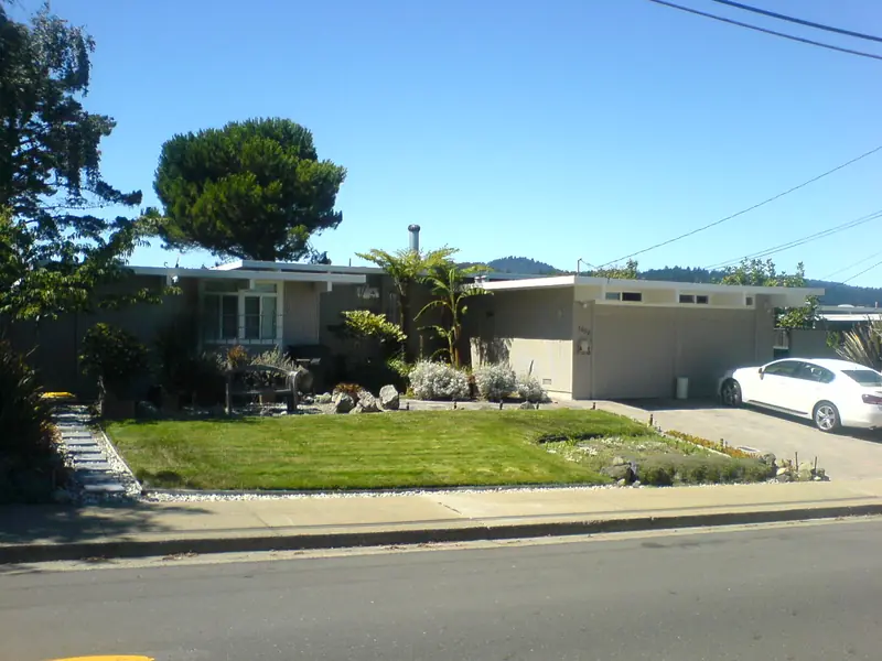

Eichler worked with leading architects. The San Francisco firm Anshen and Allen designed the early prototypes and tracts such as Charleston Meadows. The Los Angeles partnership of A. Quincy Jones and Frederick Emmons designed later tracts including Greenmeadow and Fairmeadow. Claude Oakland designed several of the later Palo Alto tracts.
Eichler Homes also adopted a policy of selling to buyers regardless of race or religion before fair housing laws required it. In 1958 Eichler resigned from the National Association of Home Builders to protest its discriminatory policies. That history matters in a region where racial covenants and redlining shaped where many families could live.
In 2018 the City Council adopted voluntary Eichler design guidelines to help owners remodel in keeping with the style. Eleven Eichler tracts also have a Single Story Overlay, a zoning rule that limits new homes to one floor and a height of about 17 feet. If you are buying, check whether the overlay applies. Our real estate guide covers the wider market.
The main neighborhoods
Neighborhood names in south Palo Alto often come from the original Eichler tract or subdivision. Boundaries are informal. Here are the ones you will hear most:
| Neighborhood | Built | What to know |
|---|---|---|
| Greenmeadow | 1954 to 1955, with a later section in 1961 to 1962 | National Register historic district with a private community center and pool |
| Fairmeadow | 1951 to 1954 | Eichler tract with concentric circular streets next to Mitchell Park |
| Charleston Meadows | 1950 to 1951 | An early Eichler tract designed with Anshen and Allen |
| Charleston Gardens | 1954 | An Eichler tract from the peak building years |
| Palo Verde | Postwar | Homes east of Middlefield Road, with an elementary school of the same name |
| Ventura | Annexed 1954 | Mixed blocks between El Camino Real and the tracks |
Greenmeadow
Greenmeadow is the showpiece. Designed by A. Quincy Jones of Jones and Emmons, it has 243 homes in two sections, 180 in Greenmeadow I and 63 in Greenmeadow II. The first residents moved in on October 31, 1954. The tract was planned around a central park, a community center and a swimming pool. Landscape architect Thomas Church designed the community center grounds.
Residents formed the Greenmeadow Community Association on July 16, 1955. Later that year they bought the community center from Eichler for $10,000, using a bank loan backed by pledges from neighbors. The association still owns the center at 303 Parkside Drive. It has held a neighborhood Fourth of July parade every year since 1955. In 2005 Greenmeadow was listed on the National Register of Historic Places as a historic district.
Fairmeadow
Fairmeadow sits beside Mitchell Park. Its streets form concentric circles, a plan it shares with the Green Gables tract in north Palo Alto. It went up in the early 1950s. The Eichler Network credits its circular site plan to the San Francisco firm Anshen and Allen. Walking or biking its loops is an easy way to see a whole Eichler neighborhood at once.
Mitchell Park, the library and Magical Bridge
Mitchell Park is the south side's main gathering place. It covers about 21 acres off East Meadow Drive, with a fenced dog park, a Little League field next door and the city's best-known playground.
Magical Bridge Playground opened in April 2015 after years of planning and private fundraising led by founder Olenka Villarreal. It was designed so that people of all ages and abilities can play together, including children and adults who use wheelchairs or have sensory or cognitive disabilities. The Magical Bridge Foundation, formed in Palo Alto in 2016, has since helped build similar playgrounds across the Bay Area and beyond. The Palo Alto playground is free and managed by the city. It is a top stop on our Palo Alto with kids guide.
Mitchell Park Library at 3700 Middlefield Road shares a building with the Mitchell Park Community Center. It is a LEED-certified building with living walls, a green roof and solar panels. The library has recently been open seven days a week, with evening hours Monday through Thursday. Check the Palo Alto City Library website for current hours.
Cubberley Community Center
A short walk south along Middlefield Road, Cubberley Community Center at 4000 Middlefield occupies the campus of the former Ellwood P. Cubberley High School. The school opened in the fall of 1956. It is remembered for the 1967 classroom experiment known as the Third Wave, in which a teacher showed students how easily a group can slide toward fascism. Budget cuts that followed Proposition 13 closed the school in 1979.
The Palo Alto Unified School District still owns the 35-acre site and leases it to the city, which has run it as a community center since 1990. Groups rent rooms, gyms and studios for classes, dance, sports, worship, music and meetings. Foothill College ran a Middlefield campus there until 2016. The Friends of the Palo Alto Library hold large used book sales at Cubberley on the second weekend of most months.
Shopping and errands
South Palo Alto is mostly residential, with small neighborhood shopping centers along Middlefield Road, El Camino Real and near the major cross streets. For a bigger grocery run, many residents head north to the Midtown shopping area or south across San Antonio Road to the large San Antonio Shopping Center in Mountain View. Restaurants cluster along El Camino Real and on California Avenue, a short ride north.
Good to know
- Most homes in Eichler tracts are private and close to the street. Enjoy the architecture from the sidewalk and do not walk up driveways.
- Greenmeadow's community center and pool are private to association members.
- Middlefield Road and Charleston Road are busy at school drop-off times.
- Public school assignments depend on the exact address. Use the Palo Alto Unified School District school finder.
Living in south Palo Alto
Families choose the south side for its parks, schools and quieter streets. Gunn High School on Arastradero Road and several elementary and middle schools serve the area, though boundaries shift over time. Our schools guide explains the district. Housing is mostly single-family, with apartments and townhomes along El Camino Real and near the Caltrain line.
The biggest neighborhood debates involve change. Original Eichlers keep being replaced by larger homes. Residents argue about two-story rebuilds, privacy and the fate of the mid-century look. The overlay zones and design guidelines are the city's main tools in that debate. For a broader picture of cost, commutes and services, read our guide to living in Palo Alto.
A self-guided Eichler and park loop
This easy bike loop takes about an hour and covers the highlights:
- Start at Mitchell Park Library on Middlefield Road and walk through Magical Bridge Playground.
- Ride the circular streets of Fairmeadow next to the park.
- Continue south to Greenmeadow and pass the community center on Parkside Drive.
- Head over to Cubberley Community Center on Middlefield Road.
- Finish north at Midtown for coffee, or west at California Avenue for lunch.
Visitors on longer stays sometimes rent a house in these quiet neighborhoods. You can browse vacation homes in Palo Alto or see our where to stay guide. To compare the south side with older parts of town, return to the neighborhoods overview.
Frequently asked questions
Is Greenmeadow on the National Register of Historic Places?
Yes. Greenmeadow and the Green Gables tract are the two Palo Alto Eichler neighborhoods listed as National Register historic districts. Both were nominated by residents and listed in 2005. Greenmeadow was designed by A. Quincy Jones of Jones and Emmons and built in the mid-1950s.
How many Eichler homes are in Palo Alto?
The city's Eichler design guidelines put the number at about 2,700, mostly in central and south Palo Alto. That is roughly 17 percent of the city's single-family houses. Palo Alto is often described as having the highest concentration of Eichlers anywhere.
What is the Magical Bridge Playground?
Magical Bridge in Mitchell Park opened in April 2015. It was designed so that children and adults of all ages and abilities can play together, including people who use wheelchairs or have sensory needs. It is free and open to the public.
What is Cubberley Community Center?
Cubberley is the former Cubberley High School campus at 4000 Middlefield Road, which closed in 1979. The school district owns the 35-acre site and leases it to the city, which has run it as a community center since 1990. Groups rent space for classes, sports, arts and meetings.
Where does south Palo Alto begin?
Most residents treat Oregon Expressway as the line between north and south Palo Alto. The core postwar neighborhoods lie further south around Middlefield Road, East Meadow Drive and Charleston Road. Midtown and Barron Park are also in the south half of the city.