On this page
Most cities are named for a person, a saint or a river. Palo Alto is named for one tree and that tree is still alive. El Palo Alto is a coast redwood growing on the bank of San Francisquito Creek, right beside the Caltrain tracks at the north end of town. Thousands of commuters pass it every day without a glance. Stop for ten minutes and you are looking at the oldest living link to Palo Alto's past.
This guide covers the tree's age and size, the lost twin trunk, the Spanish expedition of 1769, its place on the city and Stanford seals, the long fight to keep it alive and the practical details of a visit. It is free, open and easy to reach on foot from the downtown train station.
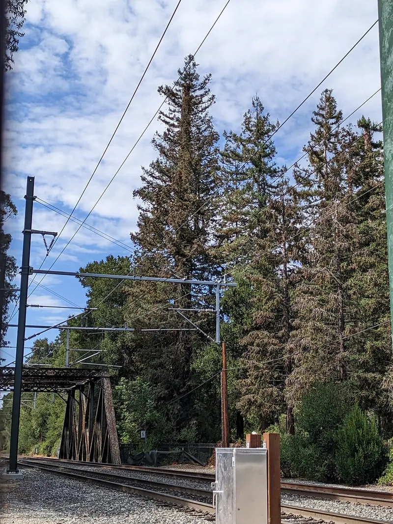

Age, height and the missing twin
El Palo Alto is more than 1,000 years old. In 1955 an increment borer pulled a core from the trunk and that sample suggests the tree sprouted around the year 940. In other words, it was already several centuries old when the first Europeans walked up the Peninsula.
Height is a different story. In 1776 the Spanish friar Pedro Font measured it at 50 varas, about 137 feet. It reached roughly 162 feet around 1930 and then began to lose its top. The commonly cited figure today is about 110 feet, from 2021. The trunk is about 90 inches across and the crown spreads around 40 feet.
The tree you see is only part of the original. Early drawings and photos show two trunks rising side by side. Carleton Watkins photographed the pair in 1870 and an 1870 sketch labeled them "Twins, once a trio." The more curved northern trunk later came down in a storm. Historians still argue about the date. Older accounts point to the late 1870s or the mid 1880s, while local researcher Jeff Watt presented evidence in 2024 that it fell in 1875. When locals counted the rings on the fallen trunk, they found roughly 960 of them.
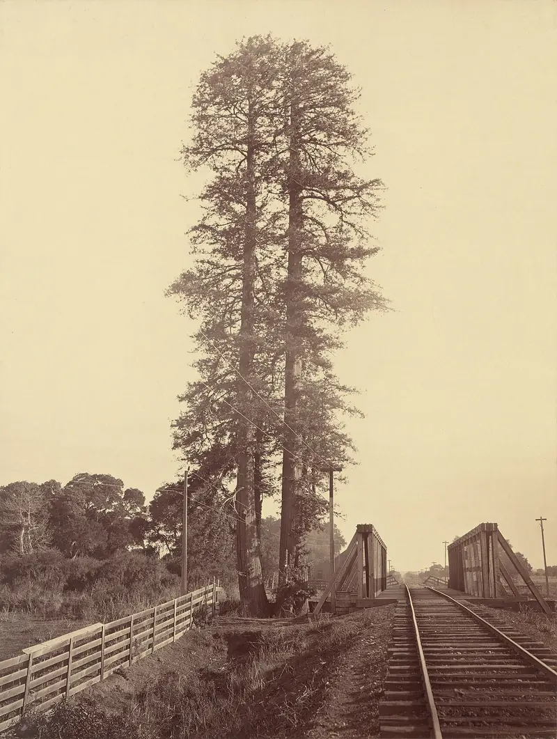

Portolá's camp in 1769
In 1769 Gaspar de Portolá led a Spanish land expedition north from San Diego in search of Monterey Bay. The party missed Monterey, kept going and became the first Europeans on record to see San Francisco Bay. On the way back south they camped by San Francisquito Creek from November 6 to 11, 1769. The tall redwood, visible for miles across the flat plain, served as their landmark while scouting parties went out.
The tree shows up in writing a few years later. Father Francisco Palóu noted the camp site in 1774 and placed a cross there to mark a possible mission. In 1776 Font measured the tree and drew it on his map, still with two trunks. The mission ended up in Santa Clara instead. Palo alto simply means tall stick or tall tree in Spanish and the name stayed with the place long after the explorers moved on.
The state recognized the story early. The nearby site known as Portolá Journey's End became California Historical Landmark No. 2 in 1932 and the tree itself was registered in 1974 as a Point of Historical Interest.
On the city and Stanford seals
When Leland and Jane Stanford built their Palo Alto Stock Farm in the 1870s, they took the name from the tree. The university they founded on that farm adopted its first official seal in 1908 with El Palo Alto in the center. The words Semper on one side and Virens on the other spell out the Latin for ever flourishing, a nod to the redwood's botanical name. The seal's artist drew a fuller, more vigorous tree than the real one.
The city uses the tree too. El Palo Alto appears on the City of Palo Alto seal and logo, so you see it on street signs, city trucks and utility bills. At Stanford football games the band's mascot is a costumed figure called the Tree, which owes its existence to the same redwood. For the bigger picture of how the town grew around the university, read our Palo Alto history.
A tree beside the railroad
The San Francisco and San Jose Railroad reached the tree in 1863 and a station nearby took the name Big Tree. Southern Pacific later took over the line and added a second track in 1902 on a trestle over the creek. By the 1920s around 70 trains a day passed within feet of the trunk. Coal and oil smoke coated the foliage for decades and many arborists blame that soot, along with a falling water table, for the dead top.
The railroad has also helped. Leland Stanford had a wooden bulkhead built to protect the creek bank after the twin fell. Jane Stanford ordered a cement wall in 1904 and Southern Pacific reinforced the bank a few years later. In 2024 Caltrain switched to electric trains, which ended the smoke problem for good. Caltrain also plans to replace the 1902 trestle, so expect construction near the tree in coming years.
A century of care
El Palo Alto has had more medical attention than most people. Here are the main steps in its care:
- 1920s: The Native Sons of the Golden West took on stewardship in 1920. Tree surgeons filled decayed cavities, sank irrigation pipes into the ground and added guy wires for support. In 1926 the group set a bronze plaque in a granite boulder under the tree and it is still there.
- 1955: A watering system nicknamed the "Fool the Redwood Plan" pumped water up to the crown to imitate coastal fog and wash off soot.
- 1961: Local arborists removed dead wood and termite damage and planted nurse trees.
- 1971: The land became a city park. Palo Alto signed a new lease with Southern Pacific in 1978.
- Today: Caretakers add soil and mulch at the base, cut dead limbs and run a pipe up the trunk to mist the treetop. Recent monitoring has used ground-penetrating radar, drone photos of the crown and a prism mounted at the top that tracks movement.
The tree has heirs too. In 1915 Stanford botany professor George James Peirce planted seven redwoods on campus as possible successors and six survive. In 2004 seedlings from El Palo Alto went to a historic tree nursery run by American Forests in Florida. By most accounts the tree is healthier now than it was a century ago.
El Palo Alto Park
The tree stands in El Palo Alto Park, a half-acre city park on the creek at Palo Alto's northern border with Menlo Park. It is small and plain: a patch of ground, the plaque on its boulder and the pedestrian and bike bridge that crosses San Francisquito Creek into Menlo Park. The boulder and plaque sit near the south end of that bridge. Nobody charges admission and there is no visitor center, so the tree is the whole show.
Good to know
- The park is reached from the end of Palo Alto Avenue near Alma Street, a short walk from the downtown Caltrain station.
- There is no parking lot. Use street parking nearby or the downtown garages.
- Stay off the railroad tracks and the creek bank. Trains pass often and fast.
- Check the city's El Palo Alto Park page for any closures during rail or creek work.
How to visit
The easiest approach is by train. Get off at the Palo Alto Caltrain station, walk north along Alma Street and turn toward the creek at Palo Alto Avenue. The walk takes about ten minutes. Our getting to Palo Alto guide covers Caltrain from San Francisco and San Jose and getting around Palo Alto explains local buses and bikes.
Here is a simple way to fit the tree into a day:
- Start downtown. Have coffee on University Avenue. Our downtown guide has the details.
- Walk to the tree. Spend 15 to 20 minutes reading the plaque and looking up the trunk from the creek side.
- Cross into campus. Walk back to the station and catch the free Marguerite shuttle or walk up Palm Drive to Stanford. Our Stanford visitor guide covers the main sights.
- Climb high. When it reopens in 2027, the Hoover Tower deck gives you a view back over the whole valley the tree once watched.
Morning light is softest for photos and a train passing behind the trunk makes the classic shot. If you want more context while you walk, a self-guided audio tour can fill in the stories. And if one redwood leaves you wanting a forest, our guide to redwood forests near Palo Alto lists the best groves within an hour's drive.
Frequently asked questions
How old is El Palo Alto?
The tree is more than 1,000 years old. A core sample taken in 1955 suggests it sprouted around the year 940. That makes it centuries older than the Spanish expedition that made it famous in 1769.
How tall is El Palo Alto?
It stands about 110 feet tall according to a 2021 figure. It was taller in the past, roughly 162 feet around 1930 and lost height as its crown died back during decades of smoke from steam trains and a falling water table.
Where exactly is El Palo Alto?
The tree stands in El Palo Alto Park on the bank of San Francisquito Creek at the northern edge of Palo Alto. Walk to the end of Palo Alto Avenue near Alma Street. The 1926 historical plaque sits by the south end of the footbridge to Menlo Park.
Why is Palo Alto named after a tree?
Palo alto means tall stick or tall tree in Spanish. Members of the Portolá expedition camped near the redwood in November 1769 and used it as a landmark. The name stuck to the area and later to the town.
Is El Palo Alto on the Stanford seal?
Yes. The first Stanford University seal, adopted in 1908, shows the tree with the words Semper Virens, Latin for ever flourishing. The tree also appears on the City of Palo Alto seal and logo.