On this page
Palo Alto is flat, laid out on a loose grid and short enough to cross on foot in an afternoon. Downtown, the California Avenue district and the Stanford campus all sit within about two miles of each other, with the Caltrain line running through the middle. Plenty of visitors arrive by train, walk everywhere they need to go and never touch a car key.
This page focuses on the walking itself: which districts work best on foot, how far apart they really are, where to cross the railroad and what to know about accessibility and walking after dark. For trains, buses and shuttles, start with our overview of getting around Palo Alto.
The most walkable districts
Downtown and University Avenue
Downtown is the easiest part of town to explore on foot. University Avenue runs from the Caltrain station east past restaurants, cafes, the Stanford Theatre and shops, with parallel streets such as Hamilton and Lytton avenues filling in the grid. Ramona Street between University and Hamilton is now permanently car-free after a City Council vote on March 10, 2025, so it works as a small pedestrian plaza. Most of the core fits inside a rectangle about half a mile long. Our downtown guide covers what to see.
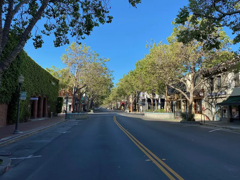

California Avenue
The California Avenue district is smaller and calmer. The street runs from the Caltrain station toward El Camino Real. The stretch between El Camino Real and Birch Street is closed to cars. Restaurant tables spill into the roadway. The Sunday farmers market fills the street year-round. See our California Avenue guide for the details.
The Stanford campus
Stanford is a walking campus at its core, though a large one. The Main Quad, Memorial Church, Hoover Tower, the Cantor Arts Center and the Rodin garden all cluster within about half a mile of each other. Bikes far outnumber cars on the inner campus, so watch for riders at every path junction. Our self-guided campus walk strings the highlights into one loop.
Residential neighborhoods
The older neighborhoods next to downtown, such as Professorville, Crescent Park and Old Palo Alto, have tree-lined streets and sidewalks that make pleasant walks between the commercial areas. Bryant Street, the city's original bike boulevard, is also a quiet walking route from downtown south toward Midtown.
Real distances between the main stops
The figures below are walking estimates based on straight-line distances from our own mapping, with an allowance for the street grid. Allow a few extra minutes at busy crossings such as El Camino Real.
| From | To | Distance on foot | Easy pace |
|---|---|---|---|
| Palo Alto Caltrain station | Lytton Plaza, mid downtown | About 0.3 miles | 5 to 7 minutes |
| Palo Alto Caltrain station | Stanford Shopping Center | About 0.5 miles | 10 minutes |
| Palo Alto Caltrain station | Cantor Arts Center | About 1 mile | 20 minutes |
| Palo Alto Caltrain station | Main Quad and Memorial Church | About 1.2 miles | 25 minutes |
| Palo Alto Caltrain station | Stanford Stadium | About 1 mile | 20 to 25 minutes |
| Downtown | California Avenue | About 1.8 to 2 miles | 35 to 45 minutes |
| California Avenue station | Main Quad | About 2 miles | 40 minutes |
| Main Quad | Hoover Tower | About 0.2 miles | 5 minutes |
Palm Drive is the classic approach to campus. It starts right behind the Caltrain station and runs straight to the Oval in front of the Main Quad under a long line of palms. It is flat with a wide path, which makes it the easiest long walk in town. Between downtown and California Avenue, Bryant or Waverley Street is quieter than Alma Street, which carries heavy traffic next to the tracks.
If a distance looks too long, the train is quick. Local and limited Caltrain trains link Palo Alto and California Avenue stations in a few minutes. On weekdays the free Marguerite shuttle runs from the transit center onto campus.
Crossing the railroad and the big roads
The Caltrain tracks split Palo Alto lengthwise. Alma Street runs right beside them. Where you cross makes a big difference to how pleasant a walk feels.
Underpasses
- University Avenue passes under the tracks next to the main station, linking downtown with Palm Drive and Stanford Shopping Center.
- The Homer Tunnel is a walking and biking tunnel a few blocks south of the station. It links the Homer Avenue side of downtown with the west side of the tracks, where the city's bike map shows the Caltrain Bike Path running beside the tracks.
- The California Avenue tunnel runs under the platforms at California Avenue station, linking the shopping street with the Park Boulevard side.
Street-level crossings
Four roads still cross the tracks at street level in Palo Alto: Palo Alto Avenue, Churchill Avenue, Meadow Drive and Charleston Road. The city lists all four in its quiet zone studies and is working on longer-term plans to separate road and rail. Electric trains are quieter than the old diesels and they accelerate fast. Never step around lowered gates. Wait until the gates rise fully before crossing, because a second train can follow the first.
El Camino Real and the expressways
El Camino Real is a wide state highway with fast traffic. Cross only at signals and give yourself the full walk phase. Oregon Expressway, Embarcadero Road and Page Mill Road are similar. In south Palo Alto the Adobe Creek bridge carries walkers and riders over US 101 to the shoreline trails.
Accessibility on foot
Downtown and the California Avenue district have curb ramps at most corners and generally smooth sidewalks. Older residential streets are a different story. Big street trees push up the pavement in places and some blocks have short gaps or narrow sections. Wheelchair users and parents with strollers do best on the main commercial streets and the Palm Drive path.
On campus, Stanford's online map has a Suggested Travel Routes layer that marks paths that are paved, lit and accessible. It is worth loading before a visit because some historic buildings have entrances on one side only. The Main Quad's arcades are level, though the sandstone paving can be uneven.
The city's 2026 Bicycle and Pedestrian Transportation Plan, adopted on June 15, 2026, calls for a walking and rolling network for people of all ages and abilities. It sets up Pedestrian Districts with a toolbox aimed at sidewalk continuity, crossing visibility and placemaking. It also targets more than 20 intersection and crossing upgrades over ten years. Adoption is a plan, not construction, so expect change to come project by project. Our accessible travel guide covers paratransit, accessible parking and transit help.
If you find a broken sidewalk, a missing curb ramp or a signal that does not give enough time to cross, report it. Our page on Palo Alto 311 explains how.
Walking after dark
Downtown stays busy into the evening, particularly Thursday to Saturday when restaurants and bars are full. University Avenue and the side streets around it are well lit. California Avenue is quieter but still has people around at dinner time.
- Residential streets are dark. Some neighborhoods have widely spaced streetlights and heavy tree cover. Carry a phone light or a small clip-on light.
- Palm Drive at night is long and fairly dark between the station and the Oval. Walk with company or use a rideshare after late events.
- Trails close. The Baylands, the Dish and the open space preserves are unlit and have closing times. Do not plan a walk there after sunset.
- Watch for bikes. Riders without lights still appear on campus paths and bike boulevards after dark.
- Earlier evenings. Daylight saving time ended on November 1, 2026, so winter sunsets come around 5 p.m. until it returns on March 14, 2027.
Stanford's Department of Public Safety and the Palo Alto Police Department both answer 911 calls in their areas. For a non-emergency, Palo Alto police dispatch is available around the clock.
Practical tips
- Mind the 20 foot rule. California now bans parking within 20 feet of a crosswalk to keep sight lines clear. Even so, drivers turning right on red often look left only, so make eye contact before you step out.
- Expect school crowds. Weekday mornings and mid-afternoons bring lots of children walking and biking near schools. Our Safe Routes to School page explains the routes.
- Bring water and shade in summer. Afternoons inland can be warm even when San Francisco is foggy.
- Stay central if you want to walk. Hotels near the main station put downtown and Palm Drive on your doorstep. You can compare hotels near the Caltrain station or read our guide to hotels near Caltrain.
Good to know
- Downtown to the Main Quad on foot takes about as long as waiting for and riding a shuttle, so walking is often the faster choice.
- Electric Caltrain trains are quiet. Look both ways at every crossing even when you hear nothing.
- Longer distance walks, such as downtown to the Baylands at about 3 miles, are better by bike. See bike rentals.
Frequently asked questions
Can you walk from downtown Palo Alto to Stanford?
Yes. From the Palo Alto Caltrain station, walk west up Palm Drive to the Oval and the Main Quad. It is about 1.2 miles and takes most people around 25 minutes on a flat, wide path. On weekdays the free Marguerite Line P covers the same stretch.
How far is California Avenue from downtown Palo Alto?
About 1.8 to 2 miles on foot depending on the route, or 35 to 45 minutes at an easy pace. Bryant Street or Waverley Street make a quieter walk than Alma Street. Caltrain covers the distance in a few minutes on local and limited trains.
Where can pedestrians cross the Caltrain tracks in Palo Alto?
The easiest crossings for walkers are the University Avenue underpass by the main station, the Homer Tunnel a few blocks south and the tunnel under California Avenue station. Street-level crossings at Palo Alto Avenue, Churchill Avenue, Meadow Drive and Charleston Road also have sidewalks. Wait for the gates to rise fully before you cross.
Is Palo Alto safe to walk at night?
Downtown and California Avenue stay lit and fairly busy into the evening, especially on weekends. Residential streets are quiet and some have little street lighting, so carry a light. Shoreline trails and open space preserves are unlit and close at night, so stick to streets after dark.
Are Palo Alto sidewalks wheelchair accessible?
Most downtown and Cal Ave sidewalks have curb ramps, but older residential streets have tree-root heaves and some gaps. Stanford's online campus map has a Suggested Travel Routes layer that marks paved, lit and accessible paths. Report a broken sidewalk through Palo Alto 311.