On this page
Mountain View wraps around Palo Alto's southeastern side. Drive down El Camino Real or Middlefield Road past San Antonio Road and you are in it. With about 82,000 residents it is larger than Palo Alto. It has a faster, younger feel. Castro Street is lined with restaurants from end to end, the train station doubles as a light rail terminal and some of the largest technology companies in the world have their headquarters here.
For a visitor based in Palo Alto, Mountain View offers three things the home city does not: a much bigger bayfront park, a major concert amphitheater and the Computer History Museum. It also has a lot more hotel rooms. This guide covers all of that plus the town's history and what it is like to live there.
Where Mountain View is
Mountain View is in Santa Clara County. It borders Palo Alto to the west and north, Los Altos to the south and Sunnyvale to the east. Highway 101 cuts across the city. North of it lies the North Bayshore district with Shoreline Park, Google's campus and the Computer History Museum. South of it are the neighborhoods, downtown and El Camino Real. NASA's Ames Research Center and Moffett Field sit on the eastern edge.
A short history
Ohlone people lived in villages between the hills and the bay for thousands of years. In 1842 the Mexican government granted more than 8,000 acres, covering most of present-day Mountain View, as Rancho Pastoria de las Borregas. The Castro family held it and Castro Street is named for them. According to the Mountain View Public Library, the settlement began around 1849 as a stagecoach stop between San Jose and San Francisco, with a blacksmith, a store, a hotel and a saloon along what is now El Camino Real. The name came from the view of the Santa Cruz Mountains.
When the railroad came through in 1864, the town center shifted to Castro Street beside the tracks. Mountain View grew as a farm town in the orchard era known as the Valley of Heart's Delight and incorporated in 1902. The Navy built an airship base at Moffett Field in the early 1930s. Its giant Hangar One still dominates the skyline. The government's aeronautics lab that became NASA Ames opened next door.
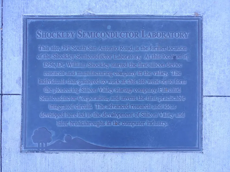
Then came the transistor. In 1956 William Shockley opened Shockley Semiconductor Laboratory at 391 San Antonio Road. Eight of his researchers left to start Fairchild Semiconductor in 1957. Fairchild's alumni went on to found Intel and many other chip companies. Our history of Shockley and the semiconductor boom covers that chain of events. A marker stands at the site today. Google moved to Mountain View from downtown Palo Alto in 1999 and is now the city's largest employer.

Downtown and Castro Street
Downtown Mountain View runs for seven blocks along Castro Street, from the transit center at the train station south to El Camino Real. The northern blocks closest to the station have the highest concentration of restaurants, cafes and bars. Many have sidewalk seating. The street is known for its range of Asian restaurants, especially Chinese, Taiwanese, Japanese and Indian, along with American and Mexican spots.
The civic core sits mid-street. City Hall, the Mountain View Center for the Performing Arts and the public library share a plaza designed by William Turnbull that opened in 1991. TheatreWorks Silicon Valley stages shows at the performing arts center, as our theater guide explains. Behind the buildings is Pioneer Park, once the town's first cemetery. A section of the Berlin Wall stands outside the library.
Shoreline and North Bayshore
Shoreline at Mountain View
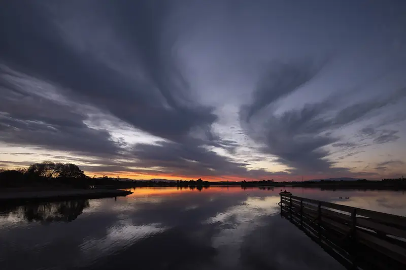
The city describes Shoreline at Mountain View as a 750-acre wildlife and recreation area. It was built on a former landfill along the bay. It includes Shoreline Lake, a golf course, tidal marshes, miles of paths and the historic Rengstorff House, a Victorian home listed on the National Register of Historic Places. The Bay Trail runs along its edge, so you can ride from the Palo Alto Baylands to Shoreline on a flat path. Sunsets over the lake are a local favorite.
Shoreline Amphitheatre
Shoreline Amphitheatre is the region's big outdoor concert venue, with a lawn and reserved seats under a tent-like canopy. The season runs mainly from spring to fall. Traffic on show nights is heavy on Shoreline Boulevard, so leave plenty of time or bike in.
Computer History Museum
The Computer History Museum at 1401 North Shoreline Boulevard is the best indoor attraction near Palo Alto for anyone curious about technology. Its exhibits cover calculating machines, mainframes, early personal computers, the internet and AI. Typical hours are Wednesday to Sunday, with the museum closed on Mondays and Tuesdays. Check the website for current hours and tickets. Allow two to three hours.

Other things to see
- Stevens Creek Trail: A paved path for walking and cycling that follows Stevens Creek through the city and down to the bay at Shoreline.
- Parks: The city says it has more than 40 parks. Cuesta Park and Rengstorff Park are the big neighborhood favorites, with play areas, picnic spots and sports facilities.
- Movies: Alamo Drafthouse opened at San Antonio Center in June 2025. Our movie theaters guide covers the options.
- Moffett Field: Hangar One is visible from Highway 101. NASA Ames does not run public tours, so enjoy it from the road.
Getting there from Palo Alto
- Caltrain: Mountain View has two stations. San Antonio is near the Palo Alto line and San Antonio Center. The Mountain View station sits at the north end of Castro Street. Both are in the same fare zone as Palo Alto. Our Caltrain guide explains schedules and fares.
- Light rail: VTA's light rail starts at the Mountain View station and heads toward Sunnyvale and San Jose.
- Free shuttles: The city's partners run the free MVgo commute shuttles and a free Community Shuttle that links neighborhoods, downtown and shopping.
- Car: Take El Camino Real or Central Expressway for downtown, or Highway 101 to the Shoreline Boulevard exit for North Bayshore.
- Bike: The Bay Trail is the scenic route to Shoreline. For downtown, Palo Alto's bike boulevards lead south toward the city line.
Where to eat and stay
Castro Street is the obvious place to eat, with dozens of restaurants within a few minutes of the train. San Antonio Center and El Camino Real add more casual options. Because restaurants open and close often here, walk the street and decide on the spot rather than planning around one place.
Mountain View has far more hotel rooms than Palo Alto. Confirmed options include the Hyatt Centric Mountain View near the San Antonio station, the Ameswell Hotel on Moffett Boulevard, a Residence Inn on El Camino Real and Hotel Zico. Our page on staying in Mountain View gives addresses and tips on picking a hotel near a station. You can also compare Mountain View hotels to see prices for your dates.
Living in Mountain View
- Housing: Mountain View has a large share of apartments and townhomes compared with its neighbors, plus mid-century neighborhoods. Monta Loma has a well-known group of Eichler homes.
- Schools: Most elementary and middle schools are in the Mountain View Whisman School District. High schools are run by the Mountain View Los Altos Union High School District, whose two main campuses each draw students from both cities.
- Government: A seven-member City Council. The council picks a mayor from among its members each year.
- Employers: Google is the largest employer. Intuit and many other technology firms also have headquarters here.
- Utilities: PG&E provides power. The city uses recycled water for landscaping in North Bayshore.
Many people who work in Palo Alto or at Stanford live in Mountain View and commute by Caltrain or bike. For the wider story of the region's tech economy, see our Silicon Valley history.
Good to know
- Concert nights at Shoreline Amphitheatre clog Shoreline Boulevard and Highway 101. Avoid the area around show times if you are not going.
- Not every Caltrain stops at San Antonio. Check the timetable.
- Parts of North Bayshore have few shops or services outside office hours. Bring water and snacks for long walks at Shoreline.
- The Shockley site is an ordinary office building today. View the marker from the sidewalk.
Frequently asked questions
How far is Mountain View from Palo Alto?
The two cities share a border. Downtown Mountain View on Castro Street is about six miles from University Avenue by road, roughly 15 to 20 minutes by car outside rush hour. Caltrain connects the two downtowns in about ten minutes.
Is the Computer History Museum worth visiting?
Yes, especially if you are interested in Silicon Valley. The museum at 1401 North Shoreline Boulevard covers more than 2,000 years of computing, from early calculating devices to AI. It is typically closed Mondays and Tuesdays, so check its website before you go.
Can you visit Google in Mountain View?
Google's main campus is a working office and most buildings are closed to the public. The exception is the Google Visitor Experience at Gradient Canopy, 2000 North Shoreline Boulevard, which opened in October 2023. Our Google Visitor Experience page has details.
What is Mountain View named after?
The town was named for its views of the Santa Cruz Mountains to the west. It began as a stagecoach stop on the road between San Francisco and San Jose and moved its center to Castro Street after the railroad arrived in 1864.
Is Mountain View cheaper than Palo Alto?
Hotels in Mountain View are often cheaper because there are many more of them. Housing is also expensive but the city has far more apartments than Palo Alto, which gives renters more choice.