On this page
Every house in Palo Alto leaves a paper trail. The county knows what it is assessed at and who holds title. The city knows how it is zoned, what permits were pulled and whether it is historic. Old maps and directories show what stood on the lot a century ago. Pulling these records before you bid can explain a strange addition, reveal an easement or show that a "bonus room" was never permitted.
This page explains which office keeps which record and how to use them. It is general information, not legal advice. A title company and a licensed agent or attorney should review the records that matter for your own purchase. For the purchase steps, see buying a home.
Who keeps which record
| Record | Office | What it tells you |
|---|---|---|
| Assessed value, APN, parcel maps | Santa Clara County Assessor | Taxable value, basic building data, parcel lines |
| Tax bills and payments | County Department of Tax and Collections | Annual and supplemental bills, special assessments, parcel taxes |
| Deeds, deeds of trust, liens, easements, CC&Rs | County Clerk-Recorder | Ownership history, loans, recorded restrictions |
| Zoning, overlays, historic and flood status | City of Palo Alto Parcel Report | What rules apply to the lot |
| Building, planning and code enforcement activity | City's Palo Alto Permit View | Permits pulled and enforcement cases |
| Flood maps | FEMA Flood Map Service Center | Official flood zone and map panel |
The county Assessor
The Santa Clara County Assessor sets the assessed value of every parcel under Proposition 13. Its online records let you look up a property by address or Assessor's Parcel Number. The APN is the most reliable key for any search, since it does not change when an address is written differently.
Assessor records are useful but limited. The assessed value usually reflects the last purchase price plus small yearly increases, not today's market. Square footage and room counts come from county files and can lag behind remodels. A large gap between the county's building data and the listing is a reason to check permits. Our property taxes page explains how assessed value, the homeowners' exemption and supplemental bills work.
The Clerk-Recorder: deeds and recorded documents
The Santa Clara County Clerk-Recorder's Office, at 110 West Tasman Drive in San Jose, records and files documents and maps for property across the county. According to the county's office page, recorded documents are available for examination and copies are issued on request. The same office collects documentary transfer tax at recording. For Palo Alto sales that is $1.10 per $1,000 for the county plus $3.30 per $1,000 for the city.
Documents you might find for a house include:
- Grant deeds showing each transfer of ownership
- Deeds of trust securing mortgages plus reconveyances when loans are paid off
- Liens such as mechanics' liens or tax liens
- Easements for utilities, shared driveways or access
- CC&Rs for condos, townhomes and some older tracts
- Subdivision and tract maps that created the lots
During a purchase, the title company pulls these records for you in the preliminary title report. Reading the underlying documents yourself helps when the report lists an easement or restriction you do not understand. The Clerk-Recorder also handles marriage licenses and other services described in our vital records guide.
Old deed restrictions
Many Palo Alto subdivisions recorded before 1950 carried racial covenants. They are void and cannot be enforced. California law now asks county recorders to help identify and remove that language. Owners can also record a modification document that strikes it from the record. Our page on covenants and the fair housing fight tells the local history.
The city's Parcel Report
For a quick read on what rules apply to a lot, start with the city's Parcel Report. You can download and print one for any address. According to the city, it includes:
- The APN and net lot size
- The zoning district and Comprehensive Plan designation
- The FEMA flood zone, map panel and any Letter of Map Amendment
- Whether the property is on the Historic Inventory, in a historic district or otherwise significant
- The county's year built and effective year built
- For R-1 lots, maximum floor area, lot coverage, height and setbacks
- Recorded easements, creek proximity, flag lot status and ADU eligibility
- Special areas such as the Airport Influence Area, groundwater plume areas and design guideline areas
The report is a starting point, not a ruling. For questions, the city's Planner on Duty answers at (650) 617-3117 or [email protected].
Permit history
Palo Alto Permit View is the city's web tool for building, planning and code enforcement activity. You can search by address, APN, date or application type, draw a custom area and subscribe to email alerts. It replaced BuildingEye, which the city said would end in late 2025. The city says more features will roll out through 2026. The page does not say how far back records go, so do not assume an empty result means no work was ever done. Questions go to [email protected].
Compare what Permit View shows with what you see in the house and on the listing. Look for permits matching:
- Additions and converted garages or carports
- New bathrooms and kitchens
- Electrical panel changes, solar and EV chargers
- Re-roofing and window replacements
- Foundation or seismic work
- ADUs and junior ADUs
Missing permits do not always mean illegal work, since older records can be incomplete. They do mean you should ask the seller. Our building permits guide explains how the city handles work done without permits.
Older files and plans
For older permit files, ask Development Services what exists for the address. Formal requests go through the city's online public records system, which our public records guide explains. California law restricts copying of building plans, so the city may require the owner's consent and sometimes the original designer's before releasing copies.
Researching a house's history
If you want to know who built a house and when, combine several sources.
- Historic Inventory files. Houses on the Palo Alto Historic Inventory often have survey forms with dates, architects and first owners. See our guide to historic homes and the inventory and our page on historic home rules.
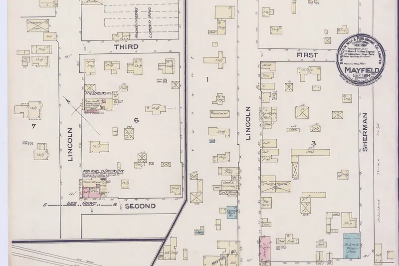
- Sanborn fire insurance maps. These detailed maps show building footprints, materials and lot lines in older parts of town and in Mayfield, the town that became south Palo Alto.
- City directories and newspapers. Local libraries and historical groups hold directories and back issues that list residents by street.
- Tract maps. For postwar homes, the recorded tract map dates the subdivision. Eichler tracts are listed with dates in the city's Eichler guidelines.

Hazard and condition records
Records also help you size up risks. Check the FEMA flood zone on the map service center and compare it with the Parcel Report. Read the seller's Natural Hazard Disclosure for fire, fault and seismic zones. Our flood zones and insurance guide explains each map. Seller inspection reports, termite reports and sewer videos are records too. Our home inspections guide explains how to read them.
A research checklist
- Find the APN on the Assessor's site or the Parcel Report.
- Download the Parcel Report and note zoning, overlays, historic status and flood zone.
- Search Permit View and list every permit by year.
- Read the preliminary title report and pull any easement or CC&R it mentions.
- Ask the seller about any work that does not appear in permits.
- Check the Historic Inventory and any survey form if the house predates 1950.
Frequently asked questions
How do I look up the permit history of a Palo Alto house?
Use Palo Alto Permit View, the city's web tool for building, planning and code enforcement activity. You can search by address, parcel number, date or application type. It replaced the older BuildingEye tool at the end of 2025. For older files or plans, ask Development Services or file a public records request.
Where are deeds recorded for Palo Alto property?
Deeds, deeds of trust, liens and other documents for Palo Alto property are recorded with the Santa Clara County Clerk-Recorder at 110 West Tasman Drive in San Jose. Recorded documents are open for examination and the office issues copies on request.
What is an APN and where do I find it?
An APN, or Assessor's Parcel Number, is the county's ID for a parcel. It appears on the property tax bill, on the city's Parcel Report and in the Santa Clara County Assessor's online records. Use it to search county and city systems when addresses are ambiguous.
How can I tell if a Palo Alto house is historic or in a flood zone?
Download the city's Parcel Report for the address. It shows the zoning district, overlays, whether the property is on the Palo Alto Historic Inventory or in a historic district, the FEMA flood zone and other details. Confirm flood zones on FEMA's map and historic status with the city's preservation planner.
Can I get the original building plans for a house?
Sometimes. Cities keep some plans with permit files, but California law limits who may copy building plans, so the city may require the owner's consent and sometimes the designer's. Ask Development Services what exists for the address before you file a request.