On this page
Huddart Park sits on the forested slope below Skyline Boulevard, a few miles above Woodside village. It covers more than 900 acres of redwood canyons, oak and madrone woodland and dry chaparral, threaded with trails that run from shady creek bottoms to the ridge. On a hot summer day the shaded canyon floor feels noticeably cooler than the valley below.
San Mateo County runs the park. It is one of the closest places to Palo Alto for a real redwood walk, though the trees are second growth rather than old-growth giants. Our Woodside and Atherton guide introduces the area. This page covers the park in depth: getting in, what it costs, which trails to choose and how it got here.
The basics
- Address: 1100 Kings Mountain Road, Woodside. The county describes the park as about 3.5 miles west of Highway 84.
- Size: The county's history page puts it at 973 acres. Its activities page says "over 900 acres."
- Hours: Open every day, including holidays, from 8 a.m. Closing time changes through the year. The county lists 6 p.m. from October 12 to November 1, 2026 and 5 p.m. from November 2, 2026 through February 2027. Check the county's hours page for later months.
- Phone: The park office is listed at (650) 851-1210.
- Facilities: Barbecue pits, picnic areas, grassy meadows, a playground, group picnic shelters, an amphitheater and a day camp area.
Entry fee and passes
Huddart is one of seven San Mateo County parks that charge a vehicle entry fee. As published by the county in October 2026, the fee is $6 per vehicle. The county's fee page lists a few ways to get in for less.
- Waived every day for veterans with proof of service and for vehicles with a disabled placard or plates.
- Waived on non-holiday weekdays for seniors 62 and older.
- Annual pass: $72, good for 12 months at all seven fee parks. Anyone can buy one.
- Library pass: San Mateo County Libraries lend park passes for three weeks.
- Day pass: A $6 pass good for one entry, redeemable for a year.
Fees change from time to time, so treat these as a guide and confirm on the county's fees and charges page. Walking or riding in from a neighboring trail does not involve a vehicle fee. Nearby Wunderlich Park and Edgewood Park are not on the county's list of fee parks.
Trails
The county notes that its online trail descriptions for Huddart are being updated after changes to the trail network, so some details there may be out of date. Download the current park map before you go. These are the routes the county describes:
| Trail | What the county says |
|---|---|
| Redwood Nature Trail | A short self-guided walk. The county also offers a self-guided tour app for the park. |
| Canyon Trail | Single track through redwood, madrone and oak. Open to hikers all year; closed to horses in the rainy season. |
| Crystal Springs Trail | Single track down the northern part of the park, linking several trails. |
| Richards Road Trail | Follows the route of an 1850s road that carried lumber from Richard's sawmill toward Redwood City. |
| Summit Springs Fire Road | Runs north to south, linking Richards Road Trail with the Archery Fire Road and crossing the Skyline Trail. |
| Skyline Trail | Runs along the upper park. It is part of the Bay Area Ridge Trail. |
Choosing a walk
For an easy visit, park near the main picnic areas and walk the Redwood Nature Trail and the canyon trails below it. For a workout, climb toward Skyline. The park rises steeply from the entrance to the ridge, so any loop that reaches the top involves a long climb back down or up. Many trails are shared with horses. Step to the downhill side and speak to the rider as horses pass. Our hiking guide compares Huddart with other hikes near Palo Alto.
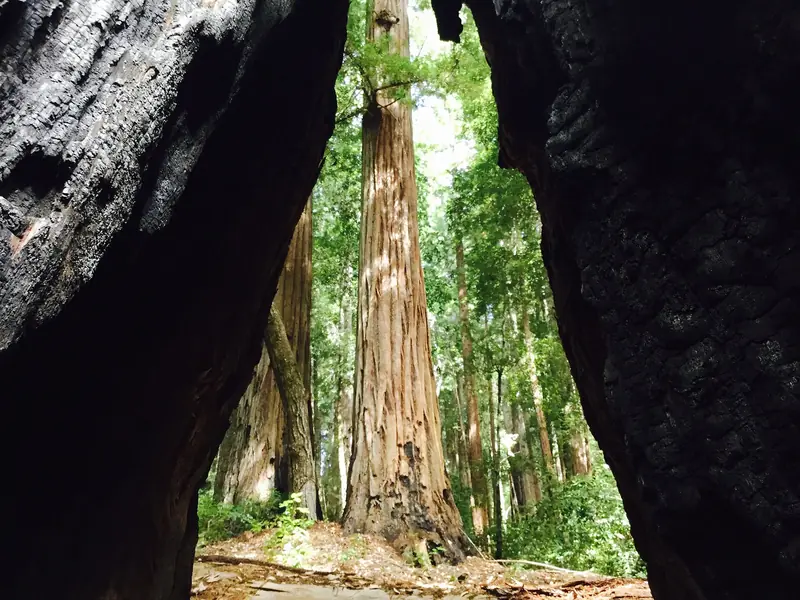

Forest and wildlife
The county describes several plant communities stacked on the slope:
- Redwood groves along creeks and gullies, with sword fern, redwood sorrel and banana slugs.
- Mixed evergreen forest over most of the park, with tanbark oak, madrone, California bay, coast live oak and Douglas fir.
- Chaparral on hot, dry slopes, with manzanita, chamise and yerba santa.
- Foothill woodland near the bottom, with valley oaks, black oaks and bay trees.
Black-tailed deer, raccoons and squirrels are common. Bobcats, coyotes and gray foxes turn up less often. Listen for acorn woodpeckers, chickadees and Steller's jays. In spring, look for hound's tongue, Indian warrior and Fremont's star lily along the trails. Poison oak grows throughout, so stay on the path.
In recent years county crews and CAL FIRE have thinned crowded young trees along park boundaries, fire roads and Kings Mountain Road to reduce wildfire risk. You may see cleared understory and stacked brush in those areas.
History
The land was part of Rancho Cañada de Raymundo, granted to John Coppinger in 1840. The Gold Rush created huge demand for lumber in San Francisco. According to the county, five sawmills operated near the present park between 1853 and 1860. Ox teams hauled lumber down the mountain on roads such as Richard's Road toward the embarcadero at Redwood City, where it was loaded onto boats. The nearby Woodside Store, covered on our Woodside village page, sat at the center of that trade.
James Huddart, a San Francisco lumberman who lived in Woodside, deeded about 900 acres to the City and County of San Francisco before his death in 1935, on condition that it become a public park. Water rights problems along Squealer Gulch Creek led San Francisco to give it up after two years. The state also ran into water rights issues. The land then went to San Mateo County, which has run it as a park since 1944.
The forest has grown back over a century. Look for the giant stumps of the original redwoods and for flat old skid roads where oxen dragged logs to the mills.
Picnics, camps and groups
Drop-in family picnic areas are first come, first served. The grassy meadow below the Werder Shelter is a favorite spot to spread out. For groups, the county takes reservations for several picnic areas, sheltered sites, group campgrounds, an amphitheater and the Sequoia Day Camp. Reservations are required for groups of 25 or more and for all youth groups. Our picnic spots guide covers places closer to Palo Alto.
Fires are allowed only in park barbecue pits. Beer and wine are permitted in certain areas, with no hard liquor. A county closure notice dated October 26, 2026 says the Toyon campground area is closed, with no running water to facilities there. Kings Mountain Archery Club maintains an archery range in the park in partnership with the county.
Rules to know
- No dogs or other pets. See our dog-friendly places guide for alternatives.
- No bikes on trails. Bicycles are allowed only on paved roads and in parking areas.
- Horses only on designated trails.
- Stay on designated trails. Do not pick plants or mushrooms.
- No drones, smoking or feeding wildlife.
Getting there from Palo Alto
Drive north on Interstate 280 to the Woodside Road exit, head west into Woodside village, then turn onto Kings Mountain Road and climb to the entrance. Allow about 30 minutes from downtown Palo Alto. There is no public transit to the park. If you are visiting without a car, you can compare rental cars for a day in the hills. Kings Mountain Road is narrow and winding, with cyclists on most weekend mornings.
Combine a morning walk with lunch in Woodside village or a visit to Filoli a few minutes north. Volunteers can join the Bay Area Ridge Trail service day at Huddart on Saturday, November 7, 2026, starting at 8:30 a.m., according to the county.
Good to know
- Expect the $6 vehicle fee as published, or carry a county annual pass.
- Winter closing time is 5 p.m. Start longer hikes by early afternoon.
- Cell coverage fades in the canyons. Download the park map first.
- Check the county's closures page for the Toyon area and trail work before a group trip.
Frequently asked questions
How much does it cost to enter Huddart Park?
San Mateo County Parks lists a vehicle entry fee of $6 at Huddart, one of seven county parks that charge one. Veterans, vehicles with disabled placards and seniors 62 and older on non-holiday weekdays can have it waived. A $72 annual pass covers all seven parks. Fees can change, so check the county's fees page.
Are dogs allowed at Huddart Park?
No. The county's regulations for Huddart say dogs and other pets are not allowed. The county keeps a list of dog-friendly trails elsewhere in its system. Service animals follow the usual rules for public places.
What are Huddart Park's hours?
The park opens at 8 a.m. every day of the year. Closing time changes with the season. The county lists 6 p.m. from October 12 to November 1, 2026 and 5 p.m. from November 2, 2026 through February 2027.
Can you see big redwoods at Huddart Park?
The forest is mostly second growth. The park was logged heavily in the 1850s, so most trees are a century or so old. You can still see huge stumps of the original trees and old skid roads where oxen dragged logs.
Can I bike at Huddart Park?
Not on the trails. The county says motor vehicles and bicycles are allowed only on paved roads and in parking areas. Horses are allowed on designated trails, so hikers share many paths with riders.