On this page
Adobe Meadow and Meadow Park are two south Palo Alto neighborhoods that share a creek, a park and a habit of looking out for each other. Until the mid-1950s this was a patchwork of rural lots and a dairy on Louis Road. A winter flood and a new flood channel changed that. Within a few years Eichlers and ranch houses filled the land between East Meadow Drive and Charleston Road. Today the streets are quiet, the block parties are long-running and the neighborhood associations are known for emergency planning.
Palo Alto Weekly profiles the two together. This guide does the same. It covers where they are, how they were built, what the homes are like and the parks, schools and shops nearby.
Where they are
Palo Alto Online describes Adobe Meadow as running from East Meadow Drive to Adobe Creek and from Middlefield Road to Louis Road. The name is literal. The neighborhood sits between Adobe Creek and Meadow Drive. Palo Alto Weekly added that the name had the bonus of coming early in the alphabet. Corina Way, Grove Avenue and part of Ross Road run through it.
Meadow Park lies just to the south, on the other side of the Adobe Creek channel and just north of East Charleston Road. A real estate blog that specializes in Eichlers places its Eichler homes on Grove Avenue, Grove Lane and Gailen Avenue, with earlier Eichlers mixed in on Bibbits Drive, Louis Road and East Charleston Road.
The neighbors are familiar names. Palo Verde begins across East Meadow Drive to the north. Fairmeadow and Mitchell Park are across Middlefield Road. Charleston Gardens and Cubberley Community Center are across Charleston Road to the south.
From dairy to tract homes
Before the houses, Adobe Meadow was rural lots. Palo Alto Online spoke with residents who remembered the late 1940s, when families on Charleston Road and Grove Avenue crossed the fields to buy milk at Piers Dairy on Louis Road.
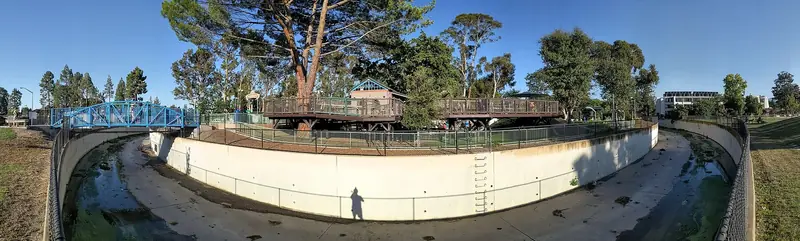
Water forced the change. A rainstorm in December 1955 flooded the area. By 1956 Adobe Creek ran in a new flood channel. Developers began building on the old dairy site that spring. Eichler homes went up that year on the south side of the new channel. The Eichler-focused blog counts about 38 Eichler homes in Meadow Park built in 1957 and 1958. Postwar ranch houses make up much of the rest.
Joseph Eichler built about 2,700 homes in Palo Alto, most of them in the southern half of the city. Our South Palo Alto guide explains the wider postwar story and the Eichler legacy.

Housing in general terms
Both neighborhoods are mostly single-family homes on suburban lots. Expect:
- single-story Eichlers with low roofs, glass walls facing the backyard and closed street fronts
- postwar ranch houses with attached garages
- remodeled originals and some larger rebuilds
Residents told Palo Alto Weekly that people rarely move away and that the area feels very stable, though street parking has grown tighter. Meadow Park formed its own association to organize around single-story overlay questions common in Eichler neighborhoods. Check current zoning with the city before planning a second story. For the market as a whole, see our real estate guide.
Block parties and emergency planning
Neighbors on Grove Avenue and Corina Way started holding block parties in the 1980s. The tradition grew into something more organized. Arthur Keller founded the Adobe Meadow Neighborhood Association in 2005. It runs a block captain system, with a volunteer for each street who knows the neighbors and can check on them after an earthquake or other emergency. During the October 2017 North Bay wildfires, when smoke drifted down the Peninsula, the association organized bulk orders of N95 masks.
That model is worth copying. Our guide to earthquakes, wildfire and emergency preparedness explains the city's own programs, including its Block Preparedness Coordinator volunteers. Meadow Park's association works alongside its neighbor. Volunteer leaders change, so use the City of Palo Alto's neighborhood association list to find current contacts.
Parks and Adobe Creek
Don Jesus Ramos Park at 800 East Meadow Drive is the neighborhood park. It hosts an annual fall neighborhood party. Mitchell Park at 600 East Meadow Drive, across Middlefield Road, is the big draw. It covers about 21 acres with Magical Bridge Playground, sports fields, a dog run and the Mitchell Park Library at 3700 Middlefield Road. See our Mitchell Park guide.
Adobe Creek runs through the area in a channel. Downstream, a bike and pedestrian bridge over US 101 near Adobe Creek has opened the shoreline to south Palo Alto riders since November 2021. From there you can join the Bay Trail.
Schools by attendance area
Palo Alto Online's profile listed Fairmeadow Elementary, Jane Lathrop Stanford Middle School and Gunn High School for the area. Fairmeadow and JLS are a short walk or ride across Middlefield Road on East Meadow Drive. Gunn is farther, on Arastradero Road across El Camino Real. Attendance areas follow specific streets and can change, so confirm any address with the PAUSD school finder.
Shops and getting around
Errands are close. Charleston Center at Middlefield and Charleston roads has Piazza's Fine Foods. The Midtown shops around Middlefield Road and Colorado Avenue are a few minutes north. Our neighborhood shopping guide has details. Cubberley Community Center at 4000 Middlefield Road hosts classes, sports and the Friends of the Palo Alto Library book sales. The Palo Alto Family YMCA on Ross Road and the Oshman Family JCC on San Antonio Road are also nearby.
Ross Road is a bike boulevard with traffic circles, including a roundabout at East Meadow Drive that opened in 2017. Many students ride it to school. VTA buses run on Middlefield Road. The nearest Caltrain stations are California Avenue and San Antonio in Mountain View, both across Alma Street.
A short walk through both
A 45 minute stroll covers the highlights. Start at Ramos Park on East Meadow Drive and wander Corina Way and the northern part of Grove Avenue in Adobe Meadow. Then head south toward Charleston Road to see the Meadow Park Eichlers on Grove Lane and Gailen Avenue, with their low rooflines and mostly windowless street fronts. Finish at Charleston Road and walk west to Charleston Center for a snack at Piazza's. To extend the outing, cross Middlefield Road into Mitchell Park and the library. Every house on this route is a private home, so stay on the sidewalk and keep photos to the street view.
Good to know
- Homes near Adobe Creek may have flood considerations. Check the flood zone status of any address.
- Middlefield Road and Charleston Road are busy at school times.
- Eichlers are private homes. View them from the street.
Visitors in town for a week or more often prefer a house near family. You can browse house rentals in Palo Alto. The flat streets and bike boulevards are ideal for a rental bike.
Frequently asked questions
Where is Adobe Meadow in Palo Alto?
Adobe Meadow is in south Palo Alto. Palo Alto Online describes it as running from East Meadow Drive to Adobe Creek and from Middlefield Road to Louis Road. Its name comes from its position between Adobe Creek and Meadow Drive.
What is the difference between Adobe Meadow and Meadow Park?
They are neighboring tracts with separate associations. Adobe Meadow lies between East Meadow Drive and Adobe Creek. Meadow Park is the cluster of Eichler streets just north of East Charleston Road, including Grove Avenue, Grove Lane and Gailen Avenue. Palo Alto Weekly profiles them together.
When were the homes in Adobe Meadow built?
Palo Alto Online reports that building began in the spring of 1956 on the site of the former Piers Dairy on Louis Road. Eichler homes went up in 1956 on the south side of the new Adobe Creek flood channel. A real estate blog that tracks Eichlers dates the Meadow Park Eichlers to 1957 and 1958.
Which schools serve Adobe Meadow and Meadow Park?
Palo Alto Online listed Fairmeadow Elementary, Jane Lathrop Stanford Middle School and Gunn High School. Attendance boundaries can change, so confirm any address with the Palo Alto Unified School District school finder.
What does the Adobe Meadow Neighborhood Association do?
It was founded in 2005 and runs a block captain system that doubles as an emergency preparedness network. During the October 2017 North Bay wildfires, when smoke reached Palo Alto, it organized bulk orders of N95 masks for neighbors, according to Palo Alto Weekly.