On this page
Before there was a Palo Alto, there was Mayfield. The little town on El Camino Real had a railroad station, stores and saloons decades before Stanford opened. Palo Alto absorbed it in 1925 and its main street became California Avenue. The town disappeared from the map, but the name never quite left. The Palo Alto Weekly profiles the residential streets around California Avenue as the Mayfield neighborhood.
Today it is one of the most urban parts of the city: condos and apartments next to older cottages, offices and civic buildings, a car-free restaurant street and a Caltrain station within a few blocks of every home. This guide covers the boundaries, history, housing, schools, parks and transit.
Where Mayfield is
Palo Alto Online draws the neighborhood between College Avenue and Oregon Expressway, from Park Boulevard to El Camino Real. That rectangle includes:
- the California Avenue business district and its station
- residential streets such as Sherman, Grant, Sheridan and Cambridge avenues
- the cross streets Birch and Ash, which run parallel to El Camino Real
- the city's Public Safety Building and the county courthouse on Grant Avenue
Boundaries overlap with other names. Evergreen Park lies just north and the two share a parking permit program. OpenStreetMap labels some Mayfield streets, such as Sheridan Avenue, as part of Evergreen Park. Ventura is across Oregon Expressway to the south. College Terrace and Stanford are across El Camino Real.
From rival town to neighborhood
Mayfield began in the 1850s around a roadhouse on El Camino Real and took its name from Mayfield Farm, a nearby property later owned by Sarah Wallis. Regular trains reached it in October 1863. By the 1880s it had stores, hotels, a newspaper, a brewery and around a dozen saloons, which made it the rowdy neighbor of dry Palo Alto when that town was founded next door.
Mayfield incorporated in 1903 and voted to ban saloons in 1904, with the ban in force by January 1905. Two decades later residents voted to join Palo Alto. The two towns consolidated on July 6, 1925. Mayfield's main street, Lincoln Avenue, was renamed California Avenue because Palo Alto already had a Lincoln Avenue. Our full history of Mayfield, Palo Alto's rival town tells the story in detail.
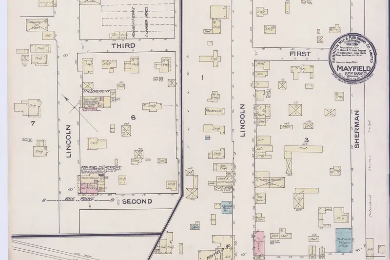

Traces remain if you look. A mural on Birch Street shows the old Mayfield railroad station. Local resident Terry Holzemer told the Weekly in 2016 that too much of Mayfield's history is ignored or forgotten. He added that the neighborhood deserves recognition as a residential area, not just a commercial and office zone.
Housing in general terms
Mayfield has more variety than most Palo Alto neighborhoods. Expect:
- Condominium complexes, such as Palo Alto Central, plus condo buildings on Sheridan Avenue.
- Apartments, from older walk-ups to newer mixed-use buildings near California Avenue.
- Single-family houses and cottages, fewer than in other neighborhoods, on blocks such as Sherman Avenue.
- Offices and civic buildings mixed in, especially near Park Boulevard and Page Mill Road.
That mix makes Mayfield one of the more accessible places in Palo Alto for renters and condo buyers. Residents told the Weekly that rising rents have pushed out some longtime apartment dwellers and that office growth and parking pressure are their main worries. Our guides to renting in Palo Alto and real estate explain the market.
Parking and city life
Parking shapes daily life here. Many residential blocks are in the Evergreen Park-Mayfield residential preferential parking program, which limits long-term daytime parking by nonresidents. Residents buy permits through the city. See our guide to residential parking permits for how it works.
Several civic buildings sit in the neighborhood. The Public Safety Building at 250 Sherman Avenue houses the police and fire departments' headquarters. The large public garage at 350 Sherman Avenue serves California Avenue visitors. The Palo Alto Courthouse is at 270 Grant Avenue. The Cambridge post office at 265 Cambridge Avenue is the branch many south Palo Alto residents use.
Shopping, food and the farmers market
Mayfield residents live next to Palo Alto's second downtown. California Avenue between El Camino Real and Birch Street is permanently closed to cars, a change the city made permanent in March 2025. Restaurants spill onto the street. The Sunday farmers market on California Avenue runs year-round. Residents interviewed by the Weekly called it one of their special community places.
For groceries, residents named Mollie Stone's and Country Sun Natural Foods at 440 California Avenue. Some also mourned the loss of service businesses, such as a hardware store and a movie theater, as restaurants took over storefronts. Our guide to shopping on California Avenue lists what is there now.
Parks and schools
Green space is limited. Palo Alto Online listed Sarah Wallis Park, a small pocket park named for the woman whose farm gave Mayfield its name. Peers Park on Park Boulevard is a short walk north in Evergreen Park. Neighbors on College Avenue have held a June picnic on a block that is already closed to through traffic at one end.
Palo Alto Online listed these public schools:
- Escondido Elementary at 890 Escondido Road, on the Stanford campus.
- Frank S. Greene Jr. Middle School at 750 North California Avenue.
- Palo Alto High School at 50 Embarcadero Road.
Confirm any address with the PAUSD school finder, since boundaries can change.
Getting around
Mayfield has the best transit of any south side neighborhood. The California Avenue Caltrain station is at the end of the street, with trains to San Francisco and San Jose. VTA Route 22 and the Rapid 522 run on El Camino Real. Route 89 links the station with Stanford Research Park and the VA hospital on weekdays. Stanford is a walk or short bike ride across El Camino.
Oregon Expressway and Page Mill Road connect drivers to US 101 and Interstate 280. Traffic on Page Mill and El Camino is heavy at rush hour.
Neighborhood groups
Mayfield has had no long-standing neighborhood association of its own. In 2016 Holzemer told the Weekly he hoped to start a Mayfield Neighborhood Association. Condo complexes such as Palo Alto Central run their own homeowners associations and events. The Evergreen Park Neighborhood Association is active just north. Check the City of Palo Alto's neighborhood association list for any current Mayfield group.
Good to know
- Read the parking signs on every block. Permit rules are enforced.
- The Sunday farmers market closes part of California Avenue to all traffic.
- Expect more noise and activity than in Palo Alto's house tracts.
Visitors who want to stay near the train and the restaurants can compare hotels near California Avenue, most of them on El Camino Real.
Frequently asked questions
Where is the Mayfield neighborhood in Palo Alto?
Palo Alto Online places Mayfield between College Avenue and Oregon Expressway, from Park Boulevard to El Camino Real. That takes in the California Avenue business district and the residential streets around it, such as Sherman, Grant and Sheridan avenues.
Was Mayfield a separate town?
Yes. Mayfield grew up in the 1850s, got its railroad station in 1863 and incorporated in 1903. It consolidated with Palo Alto on July 6, 1925. California Avenue was its main street.
Which schools serve Mayfield?
Palo Alto Online listed Escondido Elementary on the Stanford campus, Greene Middle School and Palo Alto High School. Confirm any address with the Palo Alto Unified School District school finder, since boundaries can change.
Is parking restricted in Mayfield?
Many streets are in the Evergreen Park-Mayfield residential preferential parking program, which limits long-term parking by nonresidents during the day. Check the signs on each block and the city's parking permit pages.
Does Mayfield have a neighborhood association?
Palo Alto Online's 2016 profile said residents hoped to start a Mayfield Neighborhood Association. Condo complexes such as Palo Alto Central have their own associations. Check the city's neighborhood association list for any current group.