On this page
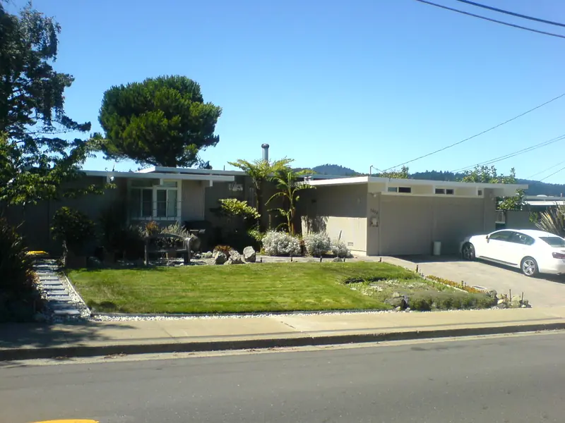
Charleston Meadows is one of the places where Joseph Eichler's Palo Alto story began. He started building in the city in 1949 and this tract followed in 1950 and 1951, designed by the San Francisco architects Anshen and Allen. It came a few years before the famous tracts of the mid 1950s, so its houses show the early version of the modern Eichler: simple plans, low roofs and big panes of glass turned toward the garden.
The neighborhood sits between El Camino Real and Alma Street at the southern edge of the city. Wide streets and cul-de-sacs keep most traffic out. This loop covers the tract, three small parks and the creek at its edge. Our Charleston Meadows neighborhood guide covers schools, shopping and daily life.
Before you go
The loop is about 2.2 miles and takes about an hour. Both figures are our estimates. It starts and ends on El Camino Real near Charleston Road. The nearest Caltrain station is San Antonio in Mountain View, just south of the city line. VTA buses on El Camino Real stop nearby.
- When to go: Weekend mornings are quiet. The low winter sun lights up the glass and wood of the houses.
- Parking: Use legal street parking on the side streets and read posted signs. Do not block driveways.
- Monday walkers: The breakfast stop at the start is closed on Mondays.
Breakfast and coffee at the start
Hobee's, at 4224 El Camino Real, is a small Bay Area chain that has served breakfast and lunch since 1974. Its menu leans on omelets, scrambles and a signature coffeecake. When our directory checked its site in late October 2026, the Palo Alto branch listed hours of 8 a.m. to 2 p.m. Tuesday to Friday and 8 a.m. to 2:30 p.m. on Saturday and Sunday. It is closed Mondays. Check the restaurant's page before you go. Our breakfast guide lists other morning spots.
The route, stop by stop
- El Camino Real at Charleston Road. Start on the old highway that forms the tract's western edge. Across the road is Barron Park. Charleston Road becomes Arastradero Road on the far side and climbs toward the foothills.
- West Charleston Road into the tract. Walk east on Charleston. Within a block the noise falls away. Notice how the houses turn mostly blank faces to the street, with a carport or garage and a few high windows.
- Whitclem Drive. Turn onto one of the quieter interior streets. A resident who moved here in 1983 told Palo Alto Online the neighborhood had a reputation for being avant garde and forward-looking. Look for the classic signs: low roofs, post-and-beam framing visible at the carport and walls of glass glimpsed between houses.
- Wilkie Way. Head to the tract's best known street. Follow it south toward the creek. Compare the original one-story houses with the larger rebuilds that have replaced some of them.
- Monroe Mini Park, Monroe Drive at Miller Avenue. Palo Alto Online lists this pocket park among the green spaces near Charleston Meadows. It makes a short rest stop between the residential blocks.
- Ventura Community Center park, 3990 Ventura Court. This city site at the northern edge has a park and playground beside buildings leased to child care programs. It also serves the Ventura neighborhood across West Meadow Drive.
- Don Secundino Robles Park, 4116 Park Boulevard. Follow Park Boulevard south. The city calls this 4.7-acre park "hidden from view," since houses surround most of it. Inside are two playgrounds, picnic tables, barbecue grills, a basketball court and a ball field. The name honors Secundino Robles, one of the brothers who bought Rancho Rincón de San Francisquito in 1847 (some sources say 1849), the land grant that once covered much of Palo Alto. Residents hold an annual fall ice cream social here. See our Robles Park guide.
- The Wilkie Way bridge over Adobe Creek. Return to Wilkie Way and walk south to the creek. A bike and pedestrian bridge carries the street across the water into Mountain View. Look down at the concrete flood channel. Upstream in Los Altos the same creek runs between natural banks under redwoods. Early railroad maps called this lower stretch the Arroyo de las Yeguas, the creek of the mares. Our Adobe Creek guide follows it from Black Mountain to the bay.
- Back to El Camino Real. Return north along Wilkie Way and west on Charleston Road to the start. If you crossed the bridge, the San Antonio shopping area in Mountain View is a few minutes on.

Why an early tract matters
Eichler's first Palo Alto tract, University Gardens, went up in 1949 and 1950. Charleston Meadows, Green Gables and Greer Park followed in 1950 and 1951, all designed by Anshen and Allen. Robert Anshen had challenged Eichler to build houses with real architecture behind them. These early tracts were the result. Later in the decade the Los Angeles firm of A. Quincy Jones and Frederick Emmons took over many of the big Palo Alto projects, including Greenmeadow and Charleston Gardens.
Eichler Homes also sold to buyers regardless of race or religion at a time when many builders refused. That policy shaped who could buy in tracts like this one in the 1950s. Our Eichler homes history covers the full list of tracts. Our Greenmeadow walking tour shows the later, larger version of the idea.
What to look for
- Closed fronts. Few street windows. Privacy faces the street and the glass faces the yard.
- Carports and garages set at the front, often with exposed beams.
- Flat or gently pitched roofs with wide overhangs.
- Vertical wood siding on many of the originals.
- Cul-de-sacs that keep cut-through traffic out, even with two major roads so close.
The city adopted voluntary Eichler design guidelines in 2018. They encourage owners to keep these features when they remodel.
Snacks at the edges
Charleston Meadows has no shops of its own, but three shopping areas sit close by. Palo Alto Online lists the Village at San Antonio in Mountain View, the Charleston Shopping Center and Alma Village. If you want an afternoon treat instead of breakfast, Rick's Ice Cream is at the Charleston Center, 3946 Middlefield Road, about a mile east across Alma Street. A Peet's Coffee at 3904 Middlefield Road is in the same center. Both make sense if you continue east toward Mitchell Park on a bike rather than on foot.
Accessibility notes
- The loop is flat. Streets inside the tract are wide and lightly used. Where a sidewalk is missing or blocked, walk facing traffic.
- El Camino Real is busy. Cross it and Charleston Road only at signals.
- The city lists no restrooms at Robles Park. Use the restaurant at the start.
- For a shorter walk of about a mile, go from the start straight down Wilkie Way to Robles Park and the bridge and back.
Sidewalk etiquette
Good to know
- Every Eichler on this route is a private home. Stay on the sidewalk or street edge.
- Never walk into carports, entry courts or atriums, even if a gate is open.
- Glass walls make residents visible. Do not photograph into homes.
- Keep groups small and voices low. Cul-de-sacs carry sound.
- Stay back from the creek channel fence, especially after rain.
Sources
Tract dates, lot counts and architects come from the city's Eichler inventory as summarized on our Eichler history page. Street and park names follow Palo Alto Online's neighborhood profile. Park details come from the city's Robles Park pages. Distances and times are our estimates.
Frequently asked questions
When was Charleston Meadows built?
Joseph Eichler built it in 1950 and 1951 with designs by the San Francisco firm Anshen and Allen. The city's Eichler list gives it 158 lots. The Eichler Network reports that the first families moved in early in 1951 while the tract was still being finished.
Is Charleston Meadows a historic district?
No. Palo Alto's two National Register Eichler districts are Greenmeadow and Green Gables. Charleston Meadows is covered by the city's voluntary Eichler design guidelines from 2018, which help owners remodel in keeping with the style.
Where is the Wilkie Way bridge?
It is a bike and pedestrian bridge that carries Wilkie Way over Adobe Creek at the south edge of Charleston Meadows. It links the neighborhood with Mountain View and the San Antonio shopping area.
Where can I eat on the Charleston Meadows walk?
Hobee's at 4224 El Camino Real, a Bay Area breakfast and lunch chain dating to 1974, is at the start. In late October 2026 it listed hours of 8 a.m. to 2 p.m. Tuesday to Friday and 8 a.m. to 2:30 p.m. on weekends. It is closed on Mondays.
Is Charleston Meadows the same as Charleston Gardens?
No. Charleston Gardens is a separate, later Eichler tract from 1954 designed by Jones and Emmons. The similar names cause confusion in listings, so check a map.